Balatonfüred geodata
Balatonfüred (Veszprém) is a seat of a second-order administrative division; located in Hungary in Europe/Budapest (GMT+2) time zone. With population of 13,055 people, there are 129 cities with bigger population in this country. Compared to other cities in Hungary, 70.6% of cities are located further ↑North; 87.6% of cities are located further →East and 77.7% of cities have lower elevation than Balatonfüred. Note1


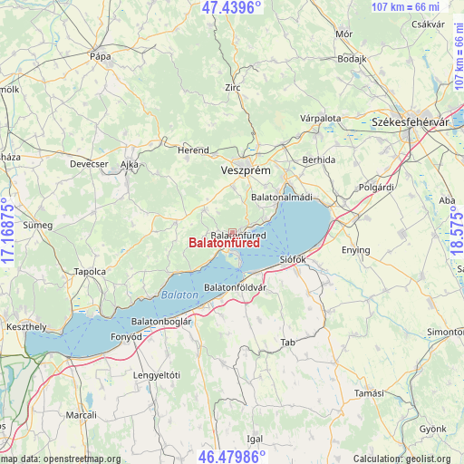
Balatonfüred GPS coordinates[2]
46° 57' 42.768" North, 17° 52' 18.732" East
| Map corner | latitude | longitude |
|---|---|---|
| Upper-left | 47.4396°, | 17.16875° |
| Center: | 46.96188°, | 17.87187° |
| Lower-right: | 46.47986°, | 18.575° |
| Map W x H: | 106.7×106.7 km | = 66.3×66.3mi |
| max Lat: | 48.46667° ⇑70.6% North |
| Balatonfüred: | 46.96188° |
| min Lat: | ⇓29.4% South 45.79108° |
| min Long | Balatonfüred | max Long |
| 16.27358° | 17.87187° | 22.68096° |
| W 12.4%⇐ | ⇒87.6% E |
Elevation
Elevation of Balatonfüred is 152 m = 499 ft, and this is 22.3 m = 73 ft above average elevation for this country.
| Max E: |
444 m = 1457 ft | 22.3% |
| Balatonfüred | 152 m 499 ft | |
| Avg. | 129.7 m = 426 ft | |
Min E: |
71 m = 233 ft | 77.7% |
See also: Hungary elevation on elevation.city.
Geographical zone
Balatonfüred is located in North temperate zone (between Tropic of Cancer and the Arctic Circle). Distance of this North polar circle is 2179.5 km =1354.3 mi to North.| Distance of | km | miles | from Balatonfüred |
|---|---|---|---|
| North Pole | 4785.4 | 2973.5 | to North |
| Arctic Circle | 2179.5 | 1354.3 | to North |
| Tropic Cancer | 2615.8 | 1625.4 | to South |
| Equator | 5221.7 | 3244.6 | to South |


Nearby cities:
15 places around Balatonfüred: (largest is in red/bold)
• Balatonalmádi
13.9 km =8.6 mi,  54°
54°
• Balatonföldvár
12.2 km =7.6 mi,  176°
176°
• Balatonkenese
19.8 km =12.3 mi,  63°
63°
• Balatonszárszó
15.2 km =9.4 mi,  193°
193°
• Bánd
19.1 km =11.9 mi,  338°
338°
• Csopak
3.9 km =2.4 mi, 64°
• Herend
21.2 km =13.2 mi,  334°
334°
• Litér
18.5 km =11.5 mi,  33°
33°
• Nemesvámos
10.4 km =6.5 mi,  1°
1°
• Siófok
15.5 km =9.6 mi,  114°
114°
• Szentkirályszabadja
13 km =8.1 mi,  35°
35°
• Tihany
5.5 km =3.4 mi,  166°
166°
• Veszprém
14.9 km =9.3 mi,  11°
11°
• Zamárdi
10.6 km =6.6 mi,  144°
144°
• Zánka
17.4 km =10.8 mi,  234°
234°
Sources, notices
• [Note1] Compared only with cities in Hungary existing in our database
• [Src1] Map data: © OpenStreetMap contributors (CC-BY-SA)
• [Src2] Other city data from geonames.org with taken over terms of usage.
• [Src3] Geographical zone / Annual Mean Temperature by Robert A. Rohde @ Wikipedia
