Nagykőrös geodata
Nagykőrös (Pest) is a seat of a second-order administrative division; located in Hungary in Europe/Budapest (GMT+2) time zone. With population of 26,711 people, there are 65 cities with bigger population in this country. Compared to other cities in Hungary, 67.8% of cities are located further ↑North; 56.8% of cities are located further ←West and 54.7% of cities have higher elevation than Nagykőrös. Note1


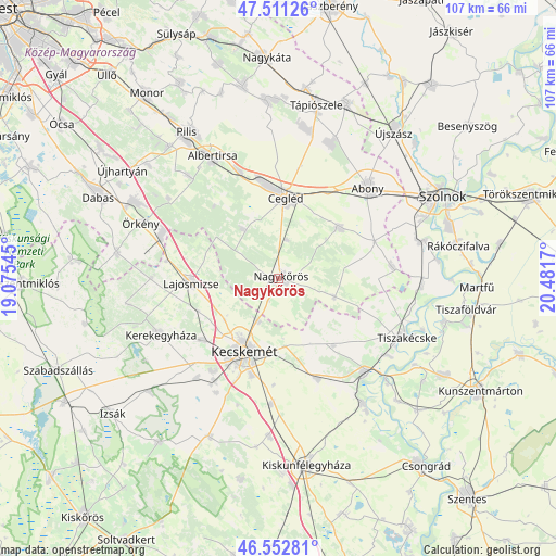
Nagykőrös GPS coordinates[2]
47° 2' 3.084" North, 19° 46' 42.852" East
| Map corner | latitude | longitude |
|---|---|---|
| Upper-left | 47.51126°, | 19.07545° |
| Center: | 47.03419°, | 19.77857° |
| Lower-right: | 46.55281°, | 20.4817° |
| Map W x H: | 106.6×106.6 km | = 66.2×66.2mi |
| max Lat: | 48.46667° ⇑67.8% North |
| Nagykőrös: | 47.03419° |
| min Lat: | ⇓32.2% South 45.79108° |
| min Long | Nagykőrös | max Long |
| 16.27358° | 19.77857° | 22.68096° |
| W 56.8%⇐ | ⇒43.2% E |
Elevation
Elevation of Nagykőrös is 113 m = 371 ft, and this is 16.7 m = 55 ft below average elevation for this country.
| Max E: |
444 m = 1457 ft | 54.7% |
| Avg. | 129.7 m = 426 ft | |
| Nagykőrös | 113 m = 371 ft | |
Min E: |
71 m = 233 ft | 45.3% |
See also: Hungary elevation on elevation.city.
Geographical zone
Nagykőrös is located in North temperate zone (between Tropic of Cancer and the Arctic Circle). Distance of this North polar circle is 2171.5 km =1349.3 mi to North.| Distance of | km | miles | from Nagykőrös |
|---|---|---|---|
| North Pole | 4777.4 | 2968.5 | to North |
| Arctic Circle | 2171.5 | 1349.3 | to North |
| Tropic Cancer | 2623.8 | 1630.4 | to South |
| Equator | 5229.7 | 3249.6 | to South |


Nearby cities:
15 places around Nagykőrös: (largest is in red/bold)
• Abony
24.3 km =15.1 mi,  44°
44°
• Ballószög
24.8 km =15.4 mi,  219°
219°
• Cegléd
15.5 km =9.6 mi,  5°
5°
• Ceglédbercel
22.7 km =14.1 mi,  338°
338°
• Csemő
11.4 km =7.1 mi,  324°
324°
• Jászkarajenő
21.9 km =13.6 mi,  85°
85°
• Kecskemét
15.7 km =9.8 mi,  204°
204°
• Kocsér
11.4 km =7.1 mi,  108°
108°
• Lajosmizse
16.5 km =10.3 mi,  265°
265°
• Lakitelek
24.1 km =15 mi,  136°
136°
• Nyárlőrinc
20.8 km =12.9 mi,  158°
158°
• Szentkirály
16.6 km =10.3 mi, 140°
• Táborfalva
23.9 km =14.9 mi,  287°
287°
• Törtel
15.5 km =9.6 mi,  50°
50°
• Városföld
24.2 km =15 mi,  183°
183°
Sources, notices
• [Note1] Compared only with cities in Hungary existing in our database
• [Src1] Map data: © OpenStreetMap contributors (CC-BY-SA)
• [Src2] Other city data from geonames.org with taken over terms of usage.
• [Src3] Geographical zone / Annual Mean Temperature by Robert A. Rohde @ Wikipedia
