Újhartyán geodata
Újhartyán (Pest) is a populated place; located in Hungary in Europe/Budapest (GMT+2) time zone. With population of 2,852 people, there are 524 cities with bigger population in this country. Compared to other cities in Hungary, 60.7% of cities are located further ↑North; 52.7% of cities are located further →East and 54.7% of cities have higher elevation than Újhartyán. Note1


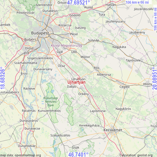
Újhartyán GPS coordinates[2]
47° 13' 11.316" North, 19° 23' 10.968" East
| Map corner | latitude | longitude |
|---|---|---|
| Upper-left | 47.69521°, | 18.68326° |
| Center: | 47.21981°, | 19.38638° |
| Lower-right: | 46.7401°, | 20.08951° |
| Map W x H: | 106.2×106.2 km | = 66×66mi |
| max Lat: | 48.46667° ⇑60.7% North |
| Újhartyán: | 47.21981° |
| min Lat: | ⇓39.3% South 45.79108° |
| min Long | Újhartyán | max Long |
| 16.27358° | 19.38638° | 22.68096° |
| W 47.3%⇐ | ⇒52.7% E |
Elevation
Elevation of Újhartyán is 113 m = 371 ft, and this is 16.7 m = 55 ft below average elevation for this country.
| Max E: |
444 m = 1457 ft | 54.7% |
| Avg. | 129.7 m = 426 ft | |
| Újhartyán | 113 m = 371 ft | |
Min E: |
71 m = 233 ft | 45.3% |
See also: Hungary elevation on elevation.city.
Geographical zone
Újhartyán is located in North temperate zone (between Tropic of Cancer and the Arctic Circle). Distance of this North polar circle is 2150.8 km =1336.4 mi to North.| Distance of | km | miles | from Újhartyán |
|---|---|---|---|
| North Pole | 4756.7 | 2955.7 | to North |
| Arctic Circle | 2150.8 | 1336.4 | to North |
| Tropic Cancer | 2644.4 | 1643.2 | to South |
| Equator | 5250.4 | 3262.4 | to South |


Nearby cities:
15 places around Újhartyán: (largest is in red/bold)
• Albertirsa
17.6 km =10.9 mi,  81°
81°
• Bugyi
18.1 km =11.2 mi,  272°
272°
• Dabas
6.8 km =4.2 mi,  236°
236°
• Dánszentmiklós
12.1 km =7.5 mi,  92°
92°
• Felsőpakony
17.8 km =11.1 mi,  320°
320°
• Hernád
7.3 km =4.5 mi,  151°
151°
• Inárcs
6.5 km =4 mi, 316°
• Kakucs
3 km =1.9 mi,  326°
326°
• Monor
15.3 km =9.5 mi,  17°
17°
• Nyáregyháza
9.9 km =6.2 mi,  61°
61°
• Pilis
14.5 km =9 mi, 57°
• Táborfalva
15.1 km =9.4 mi, 152°
• Ócsa
14.7 km =9.1 mi,  307°
307°
• Örkény
10.6 km =6.6 mi,  160°
160°
• Üllő
18.8 km =11.7 mi,  352°
352°
Sources, notices
• [Note1] Compared only with cities in Hungary existing in our database
• [Src1] Map data: © OpenStreetMap contributors (CC-BY-SA)
• [Src2] Other city data from geonames.org with taken over terms of usage.
• [Src3] Geographical zone / Annual Mean Temperature by Robert A. Rohde @ Wikipedia
