Hortobágy geodata
Hortobágy (Hajdú-Bihar) is a populated place; located in Hungary in Europe/Budapest (GMT+2) time zone. With population of 1,745 people, there are 849 cities with bigger population in this country. Compared to other cities in Hungary, 60.9% of cities are located further ↓South; 83% of cities are located further ←West and 87.7% of cities have higher elevation than Hortobágy. Note1


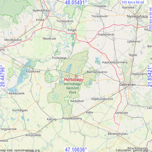
Hortobágy GPS coordinates[2]
47° 34' 58.008" North, 21° 9' 3.888" East
| Map corner | latitude | longitude |
|---|---|---|
| Upper-left | 48.05491°, | 20.44796° |
| Center: | 47.58278°, | 21.15108° |
| Lower-right: | 47.10636°, | 21.85421° |
| Map W x H: | 105.5×105.5 km | = 65.6×65.6mi |
| max Lat: | 48.46667° ⇑39.1% North |
| Hortobágy: | 47.58278° |
| min Lat: | ⇓60.9% South 45.79108° |
| min Long | Hortobágy | max Long |
| 16.27358° | 21.15108° | 22.68096° |
| W 83%⇐ | ⇒17% E |
Elevation
Elevation of Hortobágy is 88 m = 289 ft, and this is 41.7 m = 137 ft below average elevation for this country.
| Max E: |
444 m = 1457 ft | 87.7% |
| Avg. | 129.7 m = 426 ft | |
| Hortobágy | 88 m = 289 ft | |
Min E: |
71 m = 233 ft | 12.3% |
See also: Hungary elevation on elevation.city.
Geographical zone
Hortobágy is located in North temperate zone (between Tropic of Cancer and the Arctic Circle). Distance of this North polar circle is 2110.5 km =1311.4 mi to North.| Distance of | km | miles | from Hortobágy |
|---|---|---|---|
| North Pole | 4716.4 | 2930.6 | to North |
| Arctic Circle | 2110.5 | 1311.4 | to North |
| Tropic Cancer | 2684.8 | 1668.3 | to South |
| Equator | 5290.7 | 3287.5 | to South |


Nearby cities:
15 places around Hortobágy: (largest is in red/bold)
• Balmazújváros
15.4 km =9.6 mi,  75°
75°
• Ebes
29.2 km =18.1 mi,  116°
116°
• Egyek
19.6 km =12.2 mi,  286°
286°
• Görbeháza
28.5 km =17.7 mi,  12°
12°
• Hajdúböszörmény
28.9 km =18 mi,  71°
71°
• Hajdúszoboszló
23.8 km =14.8 mi,  128°
128°
• Kaba
27.7 km =17.2 mi,  158°
158°
• Kunmadaras
31.2 km =19.4 mi,  237°
237°
• Mezőcsát
31.4 km =19.5 mi,  325°
325°
• Nádudvar
18.5 km =11.5 mi,  176°
176°
• Polgár
31.7 km =19.7 mi,  355°
355°
• Püspökladány
29.7 km =18.5 mi, 184°
• Tiszacsege
17.3 km =10.7 mi,  319°
319°
• Tiszafüred
29.1 km =18.1 mi,  277°
277°
• Tiszakeszi
25 km =15.5 mi, 333°
Sources, notices
• [Note1] Compared only with cities in Hungary existing in our database
• [Src1] Map data: © OpenStreetMap contributors (CC-BY-SA)
• [Src2] Other city data from geonames.org with taken over terms of usage.
• [Src3] Geographical zone / Annual Mean Temperature by Robert A. Rohde @ Wikipedia
