Sárospatak geodata
Sárospatak (Borsod-Abaúj-Zemplén) is a seat of a second-order administrative division; located in Hungary in Europe/Budapest (GMT+2) time zone. With population of 14,478 people, there are 115 cities with bigger population in this country. Compared to other cities in Hungary, 99% of cities are located further ↓South; 88.9% of cities are located further ←West and 65.5% of cities have higher elevation than Sárospatak. Note1


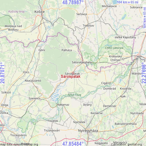
Sárospatak GPS coordinates[2]
48° 19' 28.2" North, 21° 34' 25.788" East
| Map corner | latitude | longitude |
|---|---|---|
| Upper-left | 48.78987°, | 20.87071° |
| Center: | 48.3245°, | 21.57383° |
| Lower-right: | 47.85484°, | 22.27696° |
| Map W x H: | 104×104 km | = 64.6×64.6mi |
| max Lat: | 48.46667° ⇑1% North |
| Sárospatak: | 48.3245° |
| min Lat: | ⇓99% South 45.79108° |
| min Long | Sárospatak | max Long |
| 16.27358° | 21.57383° | 22.68096° |
| W 88.9%⇐ | ⇒11.1% E |
Elevation
Elevation of Sárospatak is 106 m = 348 ft, and this is 23.7 m = 78 ft below average elevation for this country.
| Max E: |
444 m = 1457 ft | 65.5% |
| Avg. | 129.7 m = 426 ft | |
| Sárospatak | 106 m = 348 ft | |
Min E: |
71 m = 233 ft | 34.5% |
See also: Hungary elevation on elevation.city.
Geographical zone
Sárospatak is located in North temperate zone (between Tropic of Cancer and the Arctic Circle). Distance of this North polar circle is 2028 km =1260.1 mi to North.| Distance of | km | miles | from Sárospatak |
|---|---|---|---|
| North Pole | 4633.9 | 2879.4 | to North |
| Arctic Circle | 2028 | 1260.1 | to North |
| Tropic Cancer | 2767.3 | 1719.5 | to South |
| Equator | 5373.2 | 3338.8 | to South |


Nearby cities:
15 places around Sárospatak: (largest is in red/bold)
• Buj
25.6 km =15.9 mi,  167°
167°
• Cigánd
24.7 km =15.3 mi,  108°
108°
• Ibrány
24.5 km =15.2 mi,  155°
155°
• Karcsa
17.2 km =10.7 mi,  94°
94°
• Mád
26 km =16.2 mi,  236°
236°
• Nagyhalász
25.4 km =15.8 mi,  146°
146°
• Olaszliszka
13.3 km =8.3 mi,  231°
231°
• Rakamaz
23.8 km =14.8 mi,  199°
199°
• Sátoraljaújhely
10 km =6.2 mi,  38°
38°
• Tiszabercel
20.2 km =12.6 mi, 163°
• Tiszakarád
17.4 km =10.8 mi,  142°
142°
• Tiszanagyfalu
25.8 km =16 mi, 195°
• Tokaj
25.9 km =16.1 mi,  206°
206°
• Tolcsva
10.2 km =6.3 mi, 243°
• Újdombrád
26.2 km =16.3 mi,  123°
123°
Sources, notices
• [Note1] Compared only with cities in Hungary existing in our database
• [Src1] Map data: © OpenStreetMap contributors (CC-BY-SA)
• [Src2] Other city data from geonames.org with taken over terms of usage.
• [Src3] Geographical zone / Annual Mean Temperature by Robert A. Rohde @ Wikipedia
