Orosháza geodata
Orosháza (Bekes) is a seat of a second-order administrative division; located in Hungary in Europe/Budapest (GMT+2) time zone. With population of 31,373 people, there are 58 cities with bigger population in this country. Compared to other cities in Hungary, 83.9% of cities are located further ↑North; 73.8% of cities are located further ←West and 87.7% of cities have higher elevation than Orosháza. Note1


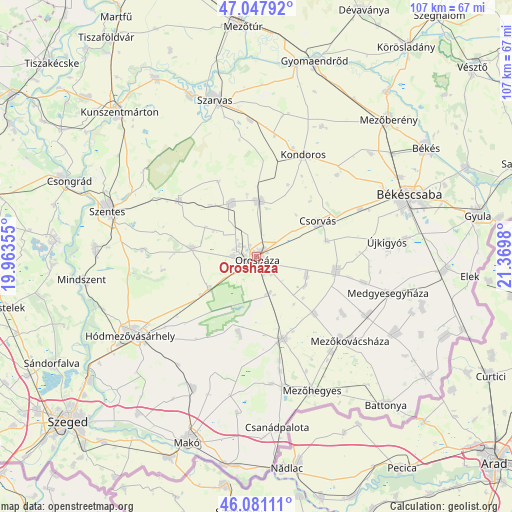
Orosháza GPS coordinates[2]
46° 34' 0.012" North, 20° 40' 0.012" East
| Map corner | latitude | longitude |
|---|---|---|
| Upper-left | 47.04792°, | 19.96355° |
| Center: | 46.56667°, | 20.66667° |
| Lower-right: | 46.08111°, | 21.3698° |
| Map W x H: | 107.5×107.5 km | = 66.8×66.8mi |
| max Lat: | 48.46667° ⇑83.9% North |
| Orosháza: | 46.56667° |
| min Lat: | ⇓16.1% South 45.79108° |
| min Long | Orosháza | max Long |
| 16.27358° | 20.66667° | 22.68096° |
| W 73.8%⇐ | ⇒26.2% E |
Elevation
Elevation of Orosháza is 88 m = 289 ft, and this is 41.7 m = 137 ft below average elevation for this country.
| Max E: |
444 m = 1457 ft | 87.7% |
| Avg. | 129.7 m = 426 ft | |
| Orosháza | 88 m = 289 ft | |
Min E: |
71 m = 233 ft | 12.3% |
See also: Hungary elevation on elevation.city.
Geographical zone
Orosháza is located in North temperate zone (between Tropic of Cancer and the Arctic Circle). Distance of this North polar circle is 2223.4 km =1381.6 mi to North.| Distance of | km | miles | from Orosháza |
|---|---|---|---|
| North Pole | 4829.3 | 3000.8 | to North |
| Arctic Circle | 2223.4 | 1381.6 | to North |
| Tropic Cancer | 2571.8 | 1598 | to South |
| Equator | 5177.7 | 3217.3 | to South |


Nearby cities:
15 places around Orosháza: (largest is in red/bold)
• Ambrózfalva
24.6 km =15.3 mi,  168°
168°
• Békéssámson
16.9 km =10.5 mi,  188°
188°
• Csanádapáca
16.7 km =10.4 mi,  96°
96°
• Csorvás
14.7 km =9.1 mi,  59°
59°
• Fábiánsebestyén
20 km =12.4 mi,  310°
310°
• Gádoros
12.2 km =7.6 mi,  335°
335°
• Kardos
26 km =16.2 mi,  8°
8°
• Kaszaper
16.9 km =10.5 mi,  131°
131°
• Kondoros
24.5 km =15.2 mi,  24°
24°
• Magyarbánhegyes
26.4 km =16.4 mi,  119°
119°
• Mezőkovácsháza
26.6 km =16.5 mi, 134°
• Nagyszénás
13 km =8.1 mi,  0°
0°
• Pusztaföldvár
10.8 km =6.7 mi,  109°
109°
• Székkutas
12.6 km =7.8 mi,  233°
233°
• Tótkomlós
17.4 km =10.8 mi,  162°
162°
Sources, notices
• [Note1] Compared only with cities in Hungary existing in our database
• [Src1] Map data: © OpenStreetMap contributors (CC-BY-SA)
• [Src2] Other city data from geonames.org with taken over terms of usage.
• [Src3] Geographical zone / Annual Mean Temperature by Robert A. Rohde @ Wikipedia
