Jászkisér geodata
Jászkisér (Jász-Nagykun-Szolnok) is a populated place; located in Hungary in Europe/Budapest (GMT+2) time zone. With population of 5,741 people, there are 266 cities with bigger population in this country. Compared to other cities in Hungary, 52.1% of cities are located further ↓South; 66.4% of cities are located further ←West and 93.3% of cities have higher elevation than Jászkisér. Note1


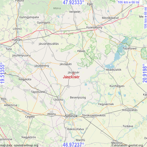
Jászkisér GPS coordinates[2]
47° 27' 0" North, 20° 13' 0.012" East
| Map corner | latitude | longitude |
|---|---|---|
| Upper-left | 47.92333°, | 19.51355° |
| Center: | 47.45°, | 20.21667° |
| Lower-right: | 46.97237°, | 20.9198° |
| Map W x H: | 105.7×105.7 km | = 65.7×65.7mi |
| max Lat: | 48.46667° ⇑47.9% North |
| Jászkisér: | 47.45° |
| min Lat: | ⇓52.1% South 45.79108° |
| min Long | Jászkisér | max Long |
| 16.27358° | 20.21667° | 22.68096° |
| W 66.4%⇐ | ⇒33.6% E |
Elevation
Elevation of Jászkisér is 85 m = 279 ft, and this is 44.7 m = 147 ft below average elevation for this country.
| Max E: |
444 m = 1457 ft | 93.3% |
| Avg. | 129.7 m = 426 ft | |
| Jászkisér | 85 m = 279 ft | |
Min E: |
71 m = 233 ft | 6.7% |
See also: Hungary elevation on elevation.city.
Geographical zone
Jászkisér is located in North temperate zone (between Tropic of Cancer and the Arctic Circle). Distance of this North polar circle is 2125.2 km =1320.5 mi to North.| Distance of | km | miles | from Jászkisér |
|---|---|---|---|
| North Pole | 4731.1 | 2939.8 | to North |
| Arctic Circle | 2125.2 | 1320.5 | to North |
| Tropic Cancer | 2670 | 1659.1 | to South |
| Equator | 5275.9 | 3278.3 | to South |


Nearby cities:
15 places around Jászkisér: (largest is in red/bold)
• Alattyán
13.4 km =8.3 mi,  258°
258°
• Besenyszög
17.1 km =10.6 mi,  167°
167°
• Heves
17.4 km =10.8 mi,  16°
16°
• Jánoshida
13.5 km =8.4 mi,  236°
236°
• Jászalsószentgyörgy
12.8 km =8 mi,  223°
223°
• Jászapáti
8.9 km =5.5 mi,  325°
325°
• Jászdózsa
19.9 km =12.4 mi,  310°
310°
• Jászjákóhalma
18.7 km =11.6 mi,  294°
294°
• Jászladány
10 km =6.2 mi,  202°
202°
• Jászszentandrás
15 km =9.3 mi,  350°
350°
• Tarnaörs
20.3 km =12.6 mi,  322°
322°
• Tiszabura
18.8 km =11.7 mi,  90°
90°
• Tiszaroff
18.4 km =11.4 mi,  107°
107°
• Tiszasüly
15.7 km =9.8 mi,  118°
118°
• Újszász
19.5 km =12.1 mi,  211°
211°
Sources, notices
• [Note1] Compared only with cities in Hungary existing in our database
• [Src1] Map data: © OpenStreetMap contributors (CC-BY-SA)
• [Src2] Other city data from geonames.org with taken over terms of usage.
• [Src3] Geographical zone / Annual Mean Temperature by Robert A. Rohde @ Wikipedia
