Jászdózsa geodata
Jászdózsa (Jász-Nagykun-Szolnok) is a populated place; located in Hungary in Europe/Budapest (GMT+2) time zone. With population of 2,225 people, there are 700 cities with bigger population in this country. Compared to other cities in Hungary, 60.4% of cities are located further ↓South; 62.4% of cities are located further ←West and 80.4% of cities have higher elevation than Jászdózsa. Note1


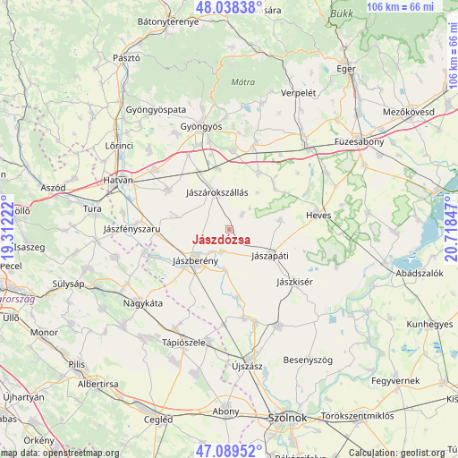
Jászdózsa GPS coordinates[2]
47° 33' 57.96" North, 20° 0' 55.224" East
| Map corner | latitude | longitude |
|---|---|---|
| Upper-left | 48.03838°, | 19.31222° |
| Center: | 47.5661°, | 20.01534° |
| Lower-right: | 47.08952°, | 20.71847° |
| Map W x H: | 105.5×105.5 km | = 65.6×65.6mi |
| max Lat: | 48.46667° ⇑39.6% North |
| Jászdózsa: | 47.5661° |
| min Lat: | ⇓60.4% South 45.79108° |
| min Long | Jászdózsa | max Long |
| 16.27358° | 20.01534° | 22.68096° |
| W 62.4%⇐ | ⇒37.6% E |
Elevation
Elevation of Jászdózsa is 95 m = 312 ft, and this is 34.7 m = 114 ft below average elevation for this country.
| Max E: |
444 m = 1457 ft | 80.4% |
| Avg. | 129.7 m = 426 ft | |
| Jászdózsa | 95 m = 312 ft | |
Min E: |
71 m = 233 ft | 19.6% |
See also: Hungary elevation on elevation.city.
Geographical zone
Jászdózsa is located in North temperate zone (between Tropic of Cancer and the Arctic Circle). Distance of this North polar circle is 2112.3 km =1312.5 mi to North.| Distance of | km | miles | from Jászdózsa |
|---|---|---|---|
| North Pole | 4718.2 | 2931.8 | to North |
| Arctic Circle | 2112.3 | 1312.5 | to North |
| Tropic Cancer | 2682.9 | 1667.1 | to South |
| Equator | 5288.9 | 3286.4 | to South |


Nearby cities:
15 places around Jászdózsa: (largest is in red/bold)
• Adács
14.3 km =8.9 mi,  348°
348°
• Alattyán
15.6 km =9.7 mi,  172°
172°
• Csány
16.6 km =10.3 mi,  303°
303°
• Gyöngyöshalász
20.6 km =12.8 mi,  341°
341°
• Heves
20.4 km =12.7 mi,  79°
79°
• Jászapáti
11.5 km =7.1 mi,  118°
118°
• Jászberény
10.4 km =6.5 mi,  225°
225°
• Jászjákóhalma
5.4 km =3.4 mi,  199°
199°
• Jászkisér
19.9 km =12.4 mi,  130°
130°
• Jászszentandrás
12.7 km =7.9 mi, 81°
• Jászárokszállás
8.9 km =5.5 mi, 342°
• Karácsond
18.2 km =11.3 mi,  3°
3°
• Szentlőrinckáta
20.4 km =12.7 mi,  255°
255°
• Tarnaörs
4.3 km =2.7 mi,  40°
40°
• Vámosgyörk
14.6 km =9.1 mi,  333°
333°
Sources, notices
• [Note1] Compared only with cities in Hungary existing in our database
• [Src1] Map data: © OpenStreetMap contributors (CC-BY-SA)
• [Src2] Other city data from geonames.org with taken over terms of usage.
• [Src3] Geographical zone / Annual Mean Temperature by Robert A. Rohde @ Wikipedia
