Jászszentandrás geodata
Jászszentandrás (Jász-Nagykun-Szolnok) is a populated place; located in Hungary in Europe/Budapest (GMT+2) time zone. With population of 2,640 people, there are 585 cities with bigger population in this country. Compared to other cities in Hungary, 61% of cities are located further ↓South; 65.4% of cities are located further ←West and 77% of cities have higher elevation than Jászszentandrás. Note1


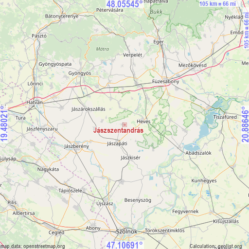
Jászszentandrás GPS coordinates[2]
47° 34' 59.988" North, 20° 10' 59.988" East
| Map corner | latitude | longitude |
|---|---|---|
| Upper-left | 48.05545°, | 19.48021° |
| Center: | 47.58333°, | 20.18333° |
| Lower-right: | 47.10691°, | 20.88646° |
| Map W x H: | 105.5×105.5 km | = 65.6×65.6mi |
| max Lat: | 48.46667° ⇑39% North |
| Jászszentandrás: | 47.58333° |
| min Lat: | ⇓61% South 45.79108° |
| min Long | Jászszentandr� | max Long |
| 16.27358° | 20.18333° | 22.68096° |
| W 65.4%⇐ | ⇒34.6% E |
Elevation
Elevation of Jászszentandrás is 97 m = 318 ft, and this is 32.7 m = 107 ft below average elevation for this country.
| Max E: |
444 m = 1457 ft | 77% |
| Avg. | 129.7 m = 426 ft | |
| Jászszentandrás | 97 m = 318 ft | |
Min E: |
71 m = 233 ft | 23% |
See also: Hungary elevation on elevation.city.
Geographical zone
Jászszentandrás is located in North temperate zone (between Tropic of Cancer and the Arctic Circle). Distance of this North polar circle is 2110.4 km =1311.3 mi to North.| Distance of | km | miles | from Jászszentandrás |
|---|---|---|---|
| North Pole | 4716.3 | 2930.6 | to North |
| Arctic Circle | 2110.4 | 1311.3 | to North |
| Tropic Cancer | 2684.9 | 1668.3 | to South |
| Equator | 5290.8 | 3287.5 | to South |


Nearby cities:
15 places around Jászszentandrás: (largest is in red/bold)
• Adács
19.6 km =12.2 mi,  308°
308°
• Alattyán
20.4 km =12.7 mi,  211°
211°
• Erdőtelek
14.9 km =9.3 mi,  41°
41°
• Heves
7.7 km =4.8 mi,  76°
76°
• Jászapáti
7.8 km =4.8 mi,  198°
198°
• Jászberény
22.1 km =13.7 mi,  245°
245°
• Jászdózsa
12.7 km =7.9 mi,  261°
261°
• Jászjákóhalma
16.1 km =10 mi,  244°
244°
• Jászkisér
15 km =9.3 mi,  170°
170°
• Jászárokszállás
16.6 km =10.3 mi,  293°
293°
• Karácsond
19.9 km =12.4 mi,  324°
324°
• Kompolt
17.4 km =10.8 mi,  16°
16°
• Kál
17.8 km =11.1 mi, 20°
• Tarnaörs
9.9 km =6.2 mi,  277°
277°
• Vámosgyörk
22.1 km =13.7 mi,  300°
300°
Sources, notices
• [Note1] Compared only with cities in Hungary existing in our database
• [Src1] Map data: © OpenStreetMap contributors (CC-BY-SA)
• [Src2] Other city data from geonames.org with taken over terms of usage.
• [Src3] Geographical zone / Annual Mean Temperature by Robert A. Rohde @ Wikipedia
