Heves geodata
Heves is a seat of a second-order administrative division; located in Hungary in Europe/Budapest (GMT+2) time zone. With population of 11,311 people, there are 146 cities with bigger population in this country. Compared to other cities in Hungary, 62.4% of cities are located further ↓South; 68% of cities are located further ←West and 78.9% of cities have higher elevation than Heves. Note1


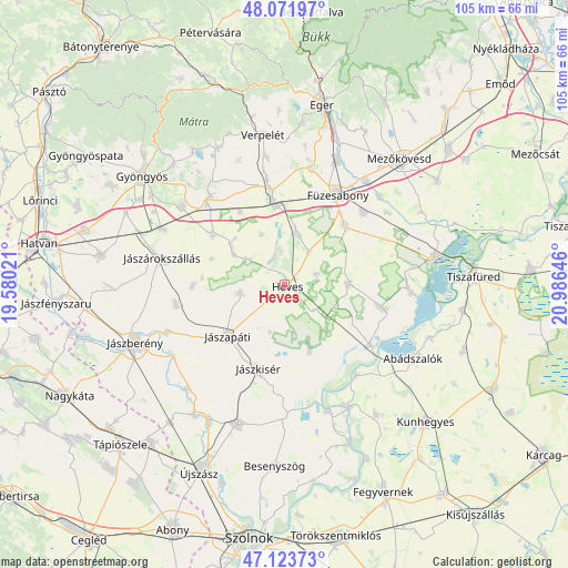
Heves GPS coordinates[2]
47° 36' 0" North, 20° 16' 59.988" East
| Map corner | latitude | longitude |
|---|---|---|
| Upper-left | 48.07197°, | 19.58021° |
| Center: | 47.6°, | 20.28333° |
| Lower-right: | 47.12373°, | 20.98646° |
| Map W x H: | 105.4×105.4 km | = 65.5×65.5mi |
| max Lat: | 48.46667° ⇑37.6% North |
| Heves: | 47.6° |
| min Lat: | ⇓62.4% South 45.79108° |
| min Long | Heves | max Long |
| 16.27358° | 20.28333° | 22.68096° |
| W 68%⇐ | ⇒32% E |
Elevation
Elevation of Heves is 96 m = 315 ft, and this is 33.7 m = 111 ft below average elevation for this country.
| Max E: |
444 m = 1457 ft | 78.9% |
| Avg. | 129.7 m = 426 ft | |
| Heves | 96 m = 315 ft | |
Min E: |
71 m = 233 ft | 21.1% |
See also: Hungary elevation on elevation.city.
Geographical zone
Heves is located in North temperate zone (between Tropic of Cancer and the Arctic Circle). Distance of this North polar circle is 2108.6 km =1310.2 mi to North.| Distance of | km | miles | from Heves |
|---|---|---|---|
| North Pole | 4714.4 | 2929.4 | to North |
| Arctic Circle | 2108.6 | 1310.2 | to North |
| Tropic Cancer | 2686.7 | 1669.4 | to South |
| Equator | 5292.6 | 3288.7 | to South |


Nearby cities:
15 places around Heves: (largest is in red/bold)
• Besenyőtelek
15.8 km =9.8 mi,  45°
45°
• Erdőtelek
9.6 km =6 mi,  15°
15°
• Füzesabony
19.4 km =12.1 mi,  30°
30°
• Jászapáti
13.6 km =8.5 mi,  227°
227°
• Jászdózsa
20.4 km =12.7 mi,  259°
259°
• Jászkisér
17.4 km =10.8 mi,  196°
196°
• Jászszentandrás
7.7 km =4.8 mi, 256°
• Jászárokszállás
23.2 km =14.4 mi,  281°
281°
• Kerecsend
22.8 km =14.2 mi,  12°
12°
• Kisköre
19.7 km =12.2 mi,  124°
124°
• Kompolt
15 km =9.3 mi,  350°
350°
• Kál
14.9 km =9.3 mi,  355°
355°
• Tarnaörs
17.3 km =10.7 mi,  268°
268°
• Tiszabura
21.6 km =13.4 mi,  140°
140°
• Tiszanána
19.1 km =11.9 mi,  101°
101°
Sources, notices
• [Note1] Compared only with cities in Hungary existing in our database
• [Src1] Map data: © OpenStreetMap contributors (CC-BY-SA)
• [Src2] Other city data from geonames.org with taken over terms of usage.
• [Src3] Geographical zone / Annual Mean Temperature by Robert A. Rohde @ Wikipedia
