Jászapáti geodata
Jászapáti (Jász-Nagykun-Szolnok) is a populated place; located in Hungary in Europe/Budapest (GMT+2) time zone. With population of 9,806 people, there are 170 cities with bigger population in this country. Compared to other cities in Hungary, 56.7% of cities are located further ↓South; 65.1% of cities are located further ←West and 80.4% of cities have higher elevation than Jászapáti. Note1


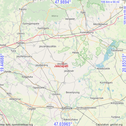
Jászapáti GPS coordinates[2]
47° 31' 0.012" North, 20° 9' 0" East
| Map corner | latitude | longitude |
|---|---|---|
| Upper-left | 47.9894°, | 19.44688° |
| Center: | 47.51667°, | 20.15° |
| Lower-right: | 47.03965°, | 20.85313° |
| Map W x H: | 105.6×105.6 km | = 65.6×65.6mi |
| max Lat: | 48.46667° ⇑43.3% North |
| Jászapáti: | 47.51667° |
| min Lat: | ⇓56.7% South 45.79108° |
| min Long | Jászapáti | max Long |
| 16.27358° | 20.15° | 22.68096° |
| W 65.1%⇐ | ⇒34.9% E |
Elevation
Elevation of Jászapáti is 95 m = 312 ft, and this is 34.7 m = 114 ft below average elevation for this country.
| Max E: |
444 m = 1457 ft | 80.4% |
| Avg. | 129.7 m = 426 ft | |
| Jászapáti | 95 m = 312 ft | |
Min E: |
71 m = 233 ft | 19.6% |
See also: Hungary elevation on elevation.city.
Geographical zone
Jászapáti is located in North temperate zone (between Tropic of Cancer and the Arctic Circle). Distance of this North polar circle is 2117.8 km =1315.9 mi to North.| Distance of | km | miles | from Jászapáti |
|---|---|---|---|
| North Pole | 4723.7 | 2935.2 | to North |
| Arctic Circle | 2117.8 | 1315.9 | to North |
| Tropic Cancer | 2677.4 | 1663.7 | to South |
| Equator | 5283.4 | 3283 | to South |


Nearby cities:
15 places around Jászapáti: (largest is in red/bold)
• Adács
23.4 km =14.5 mi,  326°
326°
• Alattyán
12.8 km =8 mi,  219°
219°
• Erdőtelek
22.4 km =13.9 mi,  33°
33°
• Heves
13.6 km =8.5 mi,  47°
47°
• Jánoshida
16.1 km =10 mi,  202°
202°
• Jászalsószentgyörgy
17.1 km =10.6 mi,  192°
192°
• Jászberény
17.6 km =10.9 mi,  263°
263°
• Jászdózsa
11.5 km =7.1 mi,  298°
298°
• Jászjákóhalma
12 km =7.5 mi,  271°
271°
• Jászkisér
8.9 km =5.5 mi,  145°
145°
• Jászladány
16.7 km =10.4 mi,  175°
175°
• Jászszentandrás
7.8 km =4.8 mi,  18°
18°
• Jászárokszállás
18.9 km =11.7 mi,  317°
317°
• Tarnaörs
11.4 km =7.1 mi, 319°
• Tiszasüly
23.9 km =14.9 mi,  128°
128°
Sources, notices
• [Note1] Compared only with cities in Hungary existing in our database
• [Src1] Map data: © OpenStreetMap contributors (CC-BY-SA)
• [Src2] Other city data from geonames.org with taken over terms of usage.
• [Src3] Geographical zone / Annual Mean Temperature by Robert A. Rohde @ Wikipedia
