Hajdúdorog geodata
Hajdúdorog (Hajdú-Bihar) is a populated place; located in Hungary in Europe/Budapest (GMT+2) time zone. With population of 9,514 people, there are 174 cities with bigger population in this country. Compared to other cities in Hungary, 78.3% of cities are located further ↓South; 88.1% of cities are located further ←West and 61.1% of cities have higher elevation than Hajdúdorog. Note1


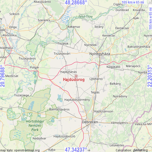
Hajdúdorog GPS coordinates[2]
47° 49' 0.012" North, 21° 30' 0" East
| Map corner | latitude | longitude |
|---|---|---|
| Upper-left | 48.28668°, | 20.79688° |
| Center: | 47.81667°, | 21.5° |
| Lower-right: | 47.34237°, | 22.20313° |
| Map W x H: | 105×105 km | = 65.2×65.2mi |
| max Lat: | 48.46667° ⇑21.7% North |
| Hajdúdorog: | 47.81667° |
| min Lat: | ⇓78.3% South 45.79108° |
| min Long | Hajdúdorog | max Long |
| 16.27358° | 21.5° | 22.68096° |
| W 88.1%⇐ | ⇒11.9% E |
Elevation
Elevation of Hajdúdorog is 109 m = 358 ft, and this is 20.7 m = 68 ft below average elevation for this country.
| Max E: |
444 m = 1457 ft | 61.1% |
| Avg. | 129.7 m = 426 ft | |
| Hajdúdorog | 109 m = 358 ft | |
Min E: |
71 m = 233 ft | 38.9% |
See also: Hungary elevation on elevation.city.
Geographical zone
Hajdúdorog is located in North temperate zone (between Tropic of Cancer and the Arctic Circle). Distance of this North polar circle is 2084.5 km =1295.2 mi to North.| Distance of | km | miles | from Hajdúdorog |
|---|---|---|---|
| North Pole | 4690.3 | 2914.4 | to North |
| Arctic Circle | 2084.5 | 1295.2 | to North |
| Tropic Cancer | 2710.8 | 1684.4 | to South |
| Equator | 5316.7 | 3303.6 | to South |


Nearby cities:
15 places around Hajdúdorog: (largest is in red/bold)
• Balmazújváros
24.9 km =15.5 mi,  206°
206°
• Bököny
20.9 km =13 mi,  116°
116°
• Görbeháza
20 km =12.4 mi,  275°
275°
• Hajdúböszörmény
16.7 km =10.4 mi,  175°
175°
• Hajdúhadház
19.4 km =12.1 mi,  139°
139°
• Hajdúnánás
6.2 km =3.9 mi,  306°
306°
• Kálmánháza
9.7 km =6 mi,  39°
39°
• Nagycserkesz
16.9 km =10.5 mi,  8°
8°
• Nyíregyháza
22.3 km =13.9 mi,  46°
46°
• Nyírtelek
24.4 km =15.2 mi,  24°
24°
• Tiszaeszlár
26.1 km =16.2 mi,  354°
354°
• Tiszalök
23.9 km =14.9 mi,  338°
338°
• Tiszavasvári
20.1 km =12.5 mi,  326°
326°
• Téglás
17.6 km =10.9 mi,  129°
129°
• Újfehértó
13.8 km =8.6 mi,  97°
97°
Sources, notices
• [Note1] Compared only with cities in Hungary existing in our database
• [Src1] Map data: © OpenStreetMap contributors (CC-BY-SA)
• [Src2] Other city data from geonames.org with taken over terms of usage.
• [Src3] Geographical zone / Annual Mean Temperature by Robert A. Rohde @ Wikipedia
