Punggur geodata
Punggur (Lampung) is a seat of a third-order administrative division; located in Indonesia in Asia/Jakarta (GMT+7) time zone. In our database, there are 407 cities with bigger population. Compared to other cities in Indonesia, 88.6% of cities are located further ↓South; 94.4% of cities are located further →East and 62.8% of cities have higher elevation than Punggur. Note1


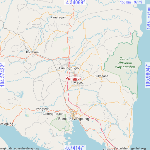
Punggur GPS coordinates[2]
5° 2' 29.256" South, 105° 16' 38.424" East
| Map corner | latitude | longitude |
|---|---|---|
| Upper-left | -4.34069°, | 104.57422° |
| Center: | -5.04146°, | 105.27734° |
| Lower-right: | -5.74147°, | 105.98047° |
| Map W x H: | 155.8×155.8 km | = 96.8×96.8mi |
| max Lat: | 5.88969° ⇑11.4% North |
| Punggur: | -5.04146° |
| min Lat: | ⇓88.6% South -10.934° |
| min Long | Punggur | max Long |
| 95.1345° | 105.27734° | 140.9419° |
| W 5.6%⇐ | ⇒94.4% E |
Elevation
Elevation of Punggur is 49 m = 161 ft, and this is 180.7 m = 593 ft below average elevation for this country.
| Max E: |
3185 m = 10449 ft | 62.8% |
| Avg. | 229.7 m = 754 ft | |
| Punggur | 49 m = 161 ft | |
Min E: |
-1 m = -3 ft | 37.2% |
See also: Indonesia elevation on elevation.city.
Geographical zone
Punggur is located in South Torrid zone (between Equator and Tropic of Capricorn). Distance of Equator is 560.6 km =348.3 mi to North.| Distance of | km | miles | from Punggur |
|---|---|---|---|
| Equator | 560.6 | 348.3 | to North |
| Tropic Capricorn | 2045.4 | 1271 | to South |
| Antarctic Circle | 6840.6 | 4250.6 | to South |
| South Pole | 9446.5 | 5869.8 | to South |


Nearby cities:
15 places around Punggur: (largest is in red/bold)
• Bandar Lampung
43.1 km =26.8 mi,  182°
182°
• Bangunrejo
28.8 km =17.9 mi,  247°
247°
• Batanghari
15.5 km =9.6 mi,  135°
135°
• Gadingrejo
43.9 km =27.3 mi,  212°
212°
• Gedong Tataan
43 km =26.7 mi, 207°
• Gunung Sugih
10.2 km =6.3 mi,  316°
316°
• Kalirejo
40.6 km =25.2 mi,  239°
239°
• Kedaton
38.1 km =23.7 mi, 182°
• Metro
8.6 km =5.3 mi,  157°
157°
• Natar
31.2 km =19.4 mi,  197°
197°
• Pekalongan
10.1 km =6.3 mi,  116°
116°
• Sekampung
20.3 km =12.6 mi, 120°
• Sukadana
30.2 km =18.8 mi,  94°
94°
• Sukoharjo Satu
43.5 km =27 mi,  228°
228°
• Terbanggi Besar
19.2 km =11.9 mi,  340°
340°
Sources, notices
• [Note1] Compared only with cities in Indonesia existing in our database
• [Src1] Map data: © OpenStreetMap contributors (CC-BY-SA)
• [Src2] Other city data from geonames.org with taken over terms of usage.
• [Src3] Geographical zone / Annual Mean Temperature by Robert A. Rohde @ Wikipedia
