Metro geodata
Metro (Lampung) is a populated place; located in Indonesia in Asia/Jakarta (GMT+7) time zone. With population of 149,526 people, there are 76 cities with bigger population in this country. Compared to other cities in Indonesia, 88.6% of cities are located further ↓South; 94.4% of cities are located further →East and 59.3% of cities have higher elevation than Metro. Note1


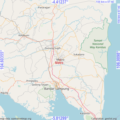
Metro GPS coordinates[2]
5° 6' 47.016" South, 105° 18' 24.012" East
| Map corner | latitude | longitude |
|---|---|---|
| Upper-left | -4.41237°, | 104.60355° |
| Center: | -5.11306°, | 105.30667° |
| Lower-right: | -5.81299°, | 106.0098° |
| Map W x H: | 155.7×155.7 km | = 96.7×96.7mi |
| max Lat: | 5.88969° ⇑11.4% North |
| Metro: | -5.11306° |
| min Lat: | ⇓88.6% South -10.934° |
| min Long | Metro | max Long |
| 95.1345° | 105.30667° | 140.9419° |
| W 5.6%⇐ | ⇒94.4% E |
Elevation
Elevation of Metro is 62 m = 203 ft, and this is 167.7 m = 550 ft below average elevation for this country.
| Max E: |
3185 m = 10449 ft | 59.3% |
| Avg. | 229.7 m = 754 ft | |
| Metro | 62 m = 203 ft | |
Min E: |
-1 m = -3 ft | 40.7% |
See also: Metro elevation on elevation.city.
Geographical zone
Metro is located in South Torrid zone (between Equator and Tropic of Capricorn). Distance of Equator is 568.5 km =353.2 mi to North.| Distance of | km | miles | from Metro |
|---|---|---|---|
| Equator | 568.5 | 353.2 | to North |
| Tropic Capricorn | 2037.4 | 1266 | to South |
| Antarctic Circle | 6832.7 | 4245.6 | to South |
| South Pole | 9438.5 | 5864.8 | to South |


Nearby cities:
15 places around Metro: (largest is in red/bold)
• Bandar Lampung
35.5 km =22.1 mi,  188°
188°
• Bangunrejo
30 km =18.6 mi,  264°
264°
• Batanghari
8.2 km =5.1 mi,  112°
112°
• Gadingrejo
39.6 km =24.6 mi,  223°
223°
• Gedong Tataan
38 km =23.6 mi, 217°
• Gunung Sugih
18.4 km =11.4 mi,  326°
326°
• Kalirejo
40.2 km =25 mi,  251°
251°
• Kedaton
30.5 km =19 mi, 189°
• Natar
25.2 km =15.7 mi,  210°
210°
• Panjang
40.4 km =25.1 mi,  177°
177°
• Pekalongan
6.7 km =4.2 mi,  59°
59°
• Punggur
8.6 km =5.3 mi,  337°
337°
• Sekampung
14.5 km =9 mi,  98°
98°
• Sukadana
27.3 km =17 mi,  78°
78°
• Terbanggi Besar
27.8 km =17.3 mi, 339°
Sources, notices
• [Note1] Compared only with cities in Indonesia existing in our database
• [Src1] Map data: © OpenStreetMap contributors (CC-BY-SA)
• [Src2] Other city data from geonames.org with taken over terms of usage.
• [Src3] Geographical zone / Annual Mean Temperature by Robert A. Rohde @ Wikipedia
