Tobadak geodata
Tobadak (West Sulawesi) is a seat of a second-order administrative division; located in Indonesia in Asia/Makassar (GMT+8) time zone. In our database, there are 407 cities with bigger population. Compared to other cities in Indonesia, 92.8% of cities are located further ↓South; 81.5% of cities are located further ←West and 78.1% of cities have higher elevation than Tobadak. Note1


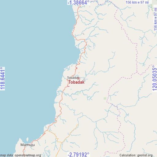
Tobadak GPS coordinates[2]
2° 5' 21.984" South, 119° 20' 49.992" East
| Map corner | latitude | longitude |
|---|---|---|
| Upper-left | -1.38664°, | 118.6441° |
| Center: | -2.08944°, | 119.34722° |
| Lower-right: | -2.79192°, | 120.05035° |
| Map W x H: | 156.3×156.3 km | = 97.1×97.1mi |
| max Lat: | 5.88969° ⇑7.2% North |
| Tobadak: | -2.08944° |
| min Lat: | ⇓92.8% South -10.934° |
| min Long | Tobadak | max Long |
| 95.1345° | 119.34722° | 140.9419° |
| W 81.5%⇐ | ⇒18.5% E |
Elevation
Elevation of Tobadak is 21 m = 69 ft, and this is 208.7 m = 685 ft below average elevation for this country.
| Max E: |
3185 m = 10449 ft | 78.1% |
| Avg. | 229.7 m = 754 ft | |
| Tobadak | 21 m = 69 ft | |
Min E: |
-1 m = -3 ft | 21.9% |
See also: Indonesia elevation on elevation.city.
Geographical zone
Tobadak is located in South Torrid zone (between Equator and Tropic of Capricorn). Distance of Equator is 232.3 km =144.3 mi to North.| Distance of | km | miles | from Tobadak |
|---|---|---|---|
| Equator | 232.3 | 144.3 | to North |
| Tropic Capricorn | 2373.6 | 1474.9 | to South |
| Antarctic Circle | 7168.9 | 4454.5 | to South |
| South Pole | 9774.7 | 6073.7 | to South |


Nearby cities:
15 places around Tobadak: (largest is in red/bold)
• Babana
16.6 km =10.3 mi,  274°
274°
• Kalumpang
45.9 km =28.5 mi,  160°
160°
• Lamasi
122.6 km =76.2 mi,  131°
131°
• Makale
125.9 km =78.2 mi,  153°
153°
• Malunda
116.3 km =72.3 mi,  207°
207°
• Mamasa
94.9 km =59 mi,  177°
177°
• Mambi
97.6 km =60.6 mi,  191°
191°
• Mamuju
83.3 km =51.8 mi,  217°
217°
• Masamba
120.6 km =74.9 mi,  115°
115°
• Rantepang
114 km =70.8 mi,  144°
144°
• Rantepao
115.5 km =71.8 mi, 148°
• Rindingallo
103.8 km =64.5 mi, 150°
• Tangratte
116.4 km =72.3 mi, 156°
• Tapalang
101.3 km =62.9 mi, 211°
• Walenrang
120 km =74.6 mi, 134°
Sources, notices
• [Note1] Compared only with cities in Indonesia existing in our database
• [Src1] Map data: © OpenStreetMap contributors (CC-BY-SA)
• [Src2] Other city data from geonames.org with taken over terms of usage.
• [Src3] Geographical zone / Annual Mean Temperature by Robert A. Rohde @ Wikipedia
