Mamuju geodata
Mamuju (West Sulawesi) is a seat of a first-order administrative division; located in Indonesia in Asia/Makassar (GMT+8) time zone. With population of 15,000 people, there are 374 cities with bigger population in this country. Compared to other cities in Indonesia, 91.9% of cities are located further ↓South; 80.5% of cities are located further ←West and 93.7% of cities have higher elevation than Mamuju. Note1


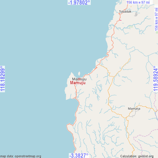
Mamuju GPS coordinates[2]
2° 40' 50.016" South, 118° 53' 9.996" East
| Map corner | latitude | longitude |
|---|---|---|
| Upper-left | -1.97802°, | 118.18299° |
| Center: | -2.68056°, | 118.88611° |
| Lower-right: | -3.3827°, | 119.58924° |
| Map W x H: | 156.2×156.2 km | = 97.1×97.1mi |
| max Lat: | 5.88969° ⇑8.1% North |
| Mamuju: | -2.68056° |
| min Lat: | ⇓91.9% South -10.934° |
| min Long | Mamuju | max Long |
| 95.1345° | 118.88611° | 140.9419° |
| W 80.5%⇐ | ⇒19.5% E |
Elevation
Elevation of Mamuju is 8 m = 26 ft, and this is 221.7 m = 727 ft below average elevation for this country.
| Max E: |
3185 m = 10449 ft | 93.7% |
| Avg. | 229.7 m = 754 ft | |
| Mamuju | 8 m = 26 ft | |
Min E: |
-1 m = -3 ft | 6.3% |
See also: Indonesia elevation on elevation.city.
Geographical zone
Mamuju is located in South Torrid zone (between Equator and Tropic of Capricorn). Distance of Equator is 298.1 km =185.2 mi to North.| Distance of | km | miles | from Mamuju |
|---|---|---|---|
| Equator | 298.1 | 185.2 | to North |
| Tropic Capricorn | 2307.9 | 1434.1 | to South |
| Antarctic Circle | 7103.1 | 4413.7 | to South |
| South Pole | 9709 | 6032.9 | to South |


Nearby cities:
15 places around Mamuju: (largest is in red/bold)
• Allu
83.6 km =51.9 mi,  171°
171°
• Babana
75.5 km =46.9 mi,  27°
27°
• Galunggalung
89.9 km =55.9 mi,  179°
179°
• Kalumpang
70.3 km =43.7 mi,  71°
71°
• Majene
96.1 km =59.7 mi, 174°
• Malunda
37.1 km =23.1 mi,  185°
185°
• Mamasa
61.8 km =38.4 mi,  118°
118°
• Mambi
43.9 km =27.3 mi,  133°
133°
• Petoosang
83.9 km =52.1 mi, 172°
• Polewali
97.8 km =60.8 mi,  148°
148°
• Rindingallo
105.8 km =65.7 mi,  103°
103°
• Somba
77.6 km =48.2 mi, 183°
• Tangratte
105.8 km =65.7 mi,  112°
112°
• Tapalang
20.5 km =12.7 mi, 185°
• Tobadak
83.3 km =51.8 mi,  37°
37°
Sources, notices
• [Note1] Compared only with cities in Indonesia existing in our database
• [Src1] Map data: © OpenStreetMap contributors (CC-BY-SA)
• [Src2] Other city data from geonames.org with taken over terms of usage.
• [Src3] Geographical zone / Annual Mean Temperature by Robert A. Rohde @ Wikipedia
