Tengah geodata
Tengah (Central Java) is a seat of a fourth-order administrative division; located in Indonesia in Asia/Jakarta (GMT+7) time zone. In our database, there are 407 cities with bigger population. Compared to other cities in Indonesia, 57.2% of cities are located further ↑North; 66.7% of cities are located further →East and 77.1% of cities have higher elevation than Tengah. Note1


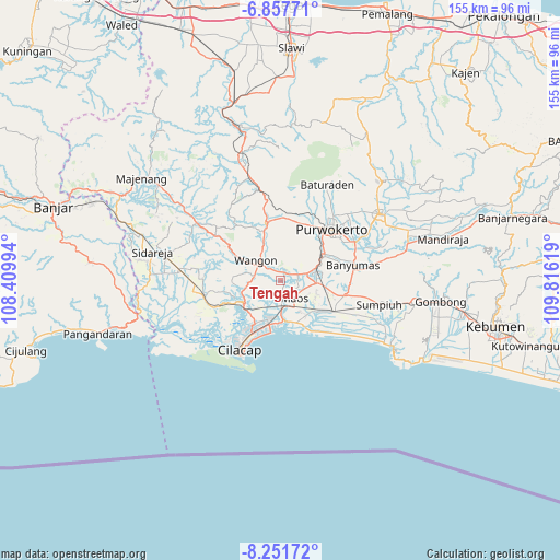
Tengah GPS coordinates[2]
7° 33' 19.008" South, 109° 6' 47.016" East
| Map corner | latitude | longitude |
|---|---|---|
| Upper-left | -6.85771°, | 108.40994° |
| Center: | -7.55528°, | 109.11306° |
| Lower-right: | -8.25172°, | 109.81619° |
| Map W x H: | 155×155 km | = 96.3×96.3mi |
| max Lat: | 5.88969° ⇑57.2% North |
| Tengah: | -7.55528° |
| min Lat: | ⇓42.8% South -10.934° |
| min Long | Tengah | max Long |
| 95.1345° | 109.11306° | 140.9419° |
| W 33.3%⇐ | ⇒66.7% E |
Elevation
Elevation of Tengah is 22 m = 72 ft, and this is 207.7 m = 681 ft below average elevation for this country.
| Max E: |
3185 m = 10449 ft | 77.1% |
| Avg. | 229.7 m = 754 ft | |
| Tengah | 22 m = 72 ft | |
Min E: |
-1 m = -3 ft | 22.9% |
See also: Indonesia elevation on elevation.city.
Geographical zone
Tengah is located in South Torrid zone (between Equator and Tropic of Capricorn). Distance of Equator is 840.1 km =522 mi to North.| Distance of | km | miles | from Tengah |
|---|---|---|---|
| Equator | 840.1 | 522 | to North |
| Tropic Capricorn | 1765.9 | 1097.3 | to South |
| Antarctic Circle | 6561.1 | 4076.9 | to South |
| South Pole | 9167 | 5696.1 | to South |


Nearby cities:
15 places around Tengah: (largest is in red/bold)
• Bantar Tengah
2.9 km =1.8 mi,  292°
292°
• Bulupayung
5.4 km =3.4 mi,  147°
147°
• Gambarjati
2.7 km =1.7 mi,  40°
40°
• Gerduren
5.2 km =3.2 mi,  334°
334°
• Jatilawang
2.4 km =1.5 mi,  17°
17°
• Kaliduren
1.7 km =1.1 mi,  251°
251°
• Karanglewas
2.9 km =1.8 mi,  86°
86°
• Keleng
4.4 km =2.7 mi,  181°
181°
• Losari
4.6 km =2.9 mi, 93°
• Margasana
3.4 km =2.1 mi,  55°
55°
• Menganti
4.8 km =3 mi,  81°
81°
• Pekuncen
0.8 km =0.5 mi,  128°
128°
• Tinggarwangi
3.7 km =2.3 mi, 17°
• Tugu
5.3 km =3.3 mi,  31°
31°
• Watuagung
4.4 km =2.7 mi, 177°
Sources, notices
• [Note1] Compared only with cities in Indonesia existing in our database
• [Src1] Map data: © OpenStreetMap contributors (CC-BY-SA)
• [Src2] Other city data from geonames.org with taken over terms of usage.
• [Src3] Geographical zone / Annual Mean Temperature by Robert A. Rohde @ Wikipedia
