Kaliduren geodata
Kaliduren (Central Java) is a seat of a fourth-order administrative division; located in Indonesia in Asia/Jakarta (GMT+7) time zone. In our database, there are 407 cities with bigger population. Compared to other cities in Indonesia, 57.4% of cities are located further ↑North; 66.7% of cities are located further →East and 74.1% of cities have higher elevation than Kaliduren. Note1


Kaliduren GPS coordinates[2]
7° 33' 37.008" South, 109° 5' 53.016" East
| Map corner | latitude | longitude |
|---|---|---|
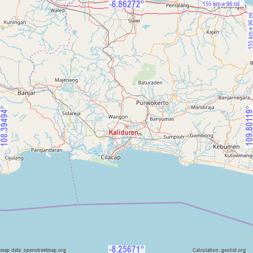
| Upper-left | -6.86272°, | 108.39494° |
| Center: | -7.56028°, | 109.09806° |
| Lower-right: | -8.25671°, | 109.80119° |
| Map W x H: | 155×155 km | = 96.3×96.3mi |
| max Lat: | 5.88969° ⇑57.4% North |
| Kaliduren: | -7.56028° |
| min Lat: | ⇓42.6% South -10.934° |
| min Long | Kaliduren | max Long |
| 95.1345° | 109.09806° | 140.9419° |
| W 33.3%⇐ | ⇒66.7% E |
Elevation
Elevation of Kaliduren is 26 m = 85 ft, and this is 203.7 m = 668 ft below average elevation for this country.
| Max E: |
3185 m = 10449 ft | 74.1% |
| Avg. | 229.7 m = 754 ft | |
| Kaliduren | 26 m = 85 ft | |
Min E: |
-1 m = -3 ft | 25.9% |
See also: Indonesia elevation on elevation.city.
Geographical zone
Kaliduren is located in South Torrid zone (between Equator and Tropic of Capricorn). Distance of Equator is 840.6 km =522.3 mi to North.| Distance of | km | miles | from Kaliduren |
|---|---|---|---|
| Equator | 840.6 | 522.3 | to North |
| Tropic Capricorn | 1765.3 | 1096.9 | to South |
| Antarctic Circle | 6560.5 | 4076.5 | to South |
| South Pole | 9166.4 | 5695.7 | to South |


Nearby cities:
15 places around Kaliduren: (largest is in red/bold)
• Bantar Tengah
1.9 km =1.2 mi,  329°
329°
• Bantarsari Kulon
4.7 km =2.9 mi,  189°
189°
• Bulupayung
6.1 km =3.8 mi,  131°
131°
• Dawuhan
5.2 km =3.2 mi,  199°
199°
• Gambarjati
4.3 km =2.7 mi,  52°
52°
• Gerduren
5.3 km =3.3 mi,  353°
353°
• Jatilawang
3.7 km =2.3 mi,  39°
39°
• Karanglewas
4.6 km =2.9 mi,  80°
80°
• Keleng
4.1 km =2.5 mi,  158°
158°
• Klapagading
5.6 km =3.5 mi, 325°
• Margasana
5.1 km =3.2 mi,  61°
61°
• Pekuncen
2.3 km =1.4 mi,  88°
88°
• Tengah
1.7 km =1.1 mi,  71°
71°
• Tinggarwangi
4.9 km =3 mi,  33°
33°
• Watuagung
4.2 km =2.6 mi,  153°
153°
Sources, notices
• [Note1] Compared only with cities in Indonesia existing in our database
• [Src1] Map data: © OpenStreetMap contributors (CC-BY-SA)
• [Src2] Other city data from geonames.org with taken over terms of usage.
• [Src3] Geographical zone / Annual Mean Temperature by Robert A. Rohde @ Wikipedia
