Klapagading geodata
Klapagading (Central Java) is a seat of a fourth-order administrative division; located in Indonesia in Asia/Jakarta (GMT+7) time zone. In our database, there are 407 cities with bigger population. Compared to other cities in Indonesia, 56.5% of cities are located further ↑North; 66.8% of cities are located further →East and 68% of cities have higher elevation than Klapagading. Note1


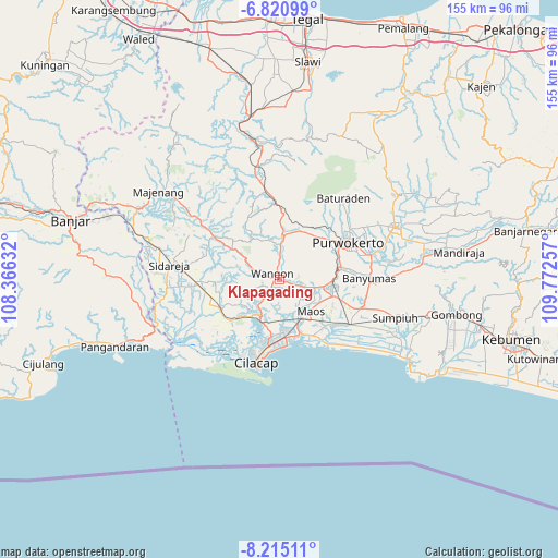
Klapagading GPS coordinates[2]
7° 31' 6.996" South, 109° 4' 9.984" East
| Map corner | latitude | longitude |
|---|---|---|
| Upper-left | -6.82099°, | 108.36632° |
| Center: | -7.51861°, | 109.06944° |
| Lower-right: | -8.21511°, | 109.77257° |
| Map W x H: | 155×155 km | = 96.3×96.3mi |
| max Lat: | 5.88969° ⇑56.5% North |
| Klapagading: | -7.51861° |
| min Lat: | ⇓43.5% South -10.934° |
| min Long | Klapagading | max Long |
| 95.1345° | 109.06944° | 140.9419° |
| W 33.2%⇐ | ⇒66.8% E |
Elevation
Elevation of Klapagading is 36 m = 118 ft, and this is 193.7 m = 635 ft below average elevation for this country.
| Max E: |
3185 m = 10449 ft | 68% |
| Avg. | 229.7 m = 754 ft | |
| Klapagading | 36 m = 118 ft | |
Min E: |
-1 m = -3 ft | 32% |
See also: Indonesia elevation on elevation.city.
Geographical zone
Klapagading is located in South Torrid zone (between Equator and Tropic of Capricorn). Distance of Equator is 836 km =519.5 mi to North.| Distance of | km | miles | from Klapagading |
|---|---|---|---|
| Equator | 836 | 519.5 | to North |
| Tropic Capricorn | 1769.9 | 1099.8 | to South |
| Antarctic Circle | 6565.2 | 4079.4 | to South |
| South Pole | 9171.1 | 5698.7 | to South |


Nearby cities:
15 places around Klapagading: (largest is in red/bold)
• Bantar Tengah
3.7 km =2.3 mi,  143°
143°
• Gambarjati
6.9 km =4.3 mi,  107°
107°
• Gerduren
2.6 km =1.6 mi,  77°
77°
• Jambuandap
7.1 km =4.4 mi,  220°
220°
• Jatilawang
5.8 km =3.6 mi, 107°
• Kaliduren
5.6 km =3.5 mi,  145°
145°
• Margasana
7.9 km =4.9 mi, 106°
• Pekuncen
7.1 km =4.4 mi,  130°
130°
• Rawaheng
3.5 km =2.2 mi,  225°
225°
• Sangkalputung
1.6 km =1 mi,  331°
331°
• Sudikampir
4.7 km =2.9 mi,  277°
277°
• Tengah
6.3 km =3.9 mi, 130°
• Tinggarwangi
5.9 km =3.7 mi,  95°
95°
• Tugu
7.5 km =4.7 mi,  86°
86°
• Wangon
1.7 km =1.1 mi, 279°
Sources, notices
• [Note1] Compared only with cities in Indonesia existing in our database
• [Src1] Map data: © OpenStreetMap contributors (CC-BY-SA)
• [Src2] Other city data from geonames.org with taken over terms of usage.
• [Src3] Geographical zone / Annual Mean Temperature by Robert A. Rohde @ Wikipedia
