Gerduren geodata
Gerduren (Central Java) is a seat of a fourth-order administrative division; located in Indonesia in Asia/Jakarta (GMT+7) time zone. In our database, there are 407 cities with bigger population. Compared to other cities in Indonesia, 56.3% of cities are located further ↑North; 66.7% of cities are located further →East and 69.5% of cities have higher elevation than Gerduren. Note1


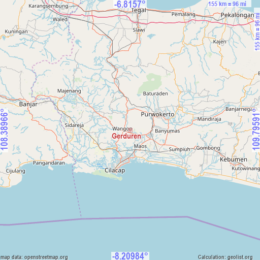
Gerduren GPS coordinates[2]
7° 30' 47.988" South, 109° 5' 34.008" East
| Map corner | latitude | longitude |
|---|---|---|
| Upper-left | -6.8157°, | 108.38966° |
| Center: | -7.51333°, | 109.09278° |
| Lower-right: | -8.20984°, | 109.79591° |
| Map W x H: | 155×155 km | = 96.3×96.3mi |
| max Lat: | 5.88969° ⇑56.3% North |
| Gerduren: | -7.51333° |
| min Lat: | ⇓43.7% South -10.934° |
| min Long | Gerduren | max Long |
| 95.1345° | 109.09278° | 140.9419° |
| W 33.3%⇐ | ⇒66.7% E |
Elevation
Elevation of Gerduren is 33 m = 108 ft, and this is 196.7 m = 645 ft below average elevation for this country.
| Max E: |
3185 m = 10449 ft | 69.5% |
| Avg. | 229.7 m = 754 ft | |
| Gerduren | 33 m = 108 ft | |
Min E: |
-1 m = -3 ft | 30.5% |
See also: Indonesia elevation on elevation.city.
Geographical zone
Gerduren is located in South Torrid zone (between Equator and Tropic of Capricorn). Distance of Equator is 835.4 km =519.1 mi to North.| Distance of | km | miles | from Gerduren |
|---|---|---|---|
| Equator | 835.4 | 519.1 | to North |
| Tropic Capricorn | 1770.5 | 1100.1 | to South |
| Antarctic Circle | 6565.8 | 4079.8 | to South |
| South Pole | 9171.7 | 5699 | to South |


Nearby cities:
15 places around Gerduren: (largest is in red/bold)
• Bantar Tengah
3.6 km =2.2 mi,  186°
186°
• Gambarjati
4.8 km =3 mi,  123°
123°
• Jatilawang
3.8 km =2.4 mi,  128°
128°
• Kaliduren
5.3 km =3.3 mi,  173°
173°
• Karanglewas
6.8 km =4.2 mi, 131°
• Klapagading
2.6 km =1.6 mi,  257°
257°
• Margasana
5.7 km =3.5 mi, 118°
• Pekuncen
5.9 km =3.7 mi,  151°
151°
• Rawaheng
5.9 km =3.7 mi,  238°
238°
• Sangkalputung
3.4 km =2.1 mi,  283°
283°
• Tengah
5.2 km =3.2 mi, 154°
• Tinggarwangi
3.5 km =2.2 mi,  109°
109°
• Tipar
6.2 km =3.9 mi,  81°
81°
• Tugu
5 km =3.1 mi,  91°
91°
• Wangon
4.3 km =2.7 mi,  265°
265°
Sources, notices
• [Note1] Compared only with cities in Indonesia existing in our database
• [Src1] Map data: © OpenStreetMap contributors (CC-BY-SA)
• [Src2] Other city data from geonames.org with taken over terms of usage.
• [Src3] Geographical zone / Annual Mean Temperature by Robert A. Rohde @ Wikipedia
