Bantar Tengah geodata
Bantar Tengah (Central Java) is a seat of a fourth-order administrative division; located in Indonesia in Asia/Jakarta (GMT+7) time zone. In our database, there are 407 cities with bigger population. Compared to other cities in Indonesia, 57% of cities are located further ↑North; 66.8% of cities are located further →East and 74.1% of cities have higher elevation than Bantar Tengah. Note1


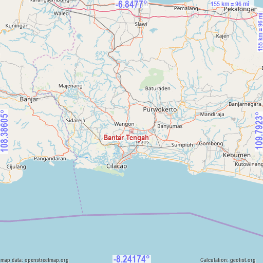
Bantar Tengah GPS coordinates[2]
7° 32' 43.008" South, 109° 5' 21.012" East
| Map corner | latitude | longitude |
|---|---|---|
| Upper-left | -6.8477°, | 108.38605° |
| Center: | -7.54528°, | 109.08917° |
| Lower-right: | -8.24174°, | 109.7923° |
| Map W x H: | 155×155 km | = 96.3×96.3mi |
| max Lat: | 5.88969° ⇑57% North |
| Bantar Tengah: | -7.54528° |
| min Lat: | ⇓43% South -10.934° |
| min Long | Bantar Tengah | max Long |
| 95.1345° | 109.08917° | 140.9419° |
| W 33.2%⇐ | ⇒66.8% E |
Elevation
Elevation of Bantar Tengah is 26 m = 85 ft, and this is 203.7 m = 668 ft below average elevation for this country.
| Max E: |
3185 m = 10449 ft | 74.1% |
| Avg. | 229.7 m = 754 ft | |
| Bantar Tengah | 26 m = 85 ft | |
Min E: |
-1 m = -3 ft | 25.9% |
See also: Indonesia elevation on elevation.city.
Geographical zone
Bantar Tengah is located in South Torrid zone (between Equator and Tropic of Capricorn). Distance of Equator is 839 km =521.3 mi to North.| Distance of | km | miles | from Bantar Tengah |
|---|---|---|---|
| Equator | 839 | 521.3 | to North |
| Tropic Capricorn | 1767 | 1098 | to South |
| Antarctic Circle | 6562.2 | 4077.6 | to South |
| South Pole | 9168.1 | 5696.8 | to South |


Nearby cities:
15 places around Bantar Tengah: (largest is in red/bold)
• Gambarjati
4.5 km =2.8 mi,  78°
78°
• Gerduren
3.6 km =2.2 mi,  6°
6°
• Jatilawang
3.6 km =2.2 mi,  70°
70°
• Kaliduren
1.9 km =1.2 mi,  149°
149°
• Karanglewas
5.6 km =3.5 mi,  99°
99°
• Keleng
6.1 km =3.8 mi,  155°
155°
• Klapagading
3.7 km =2.3 mi,  323°
323°
• Margasana
5.5 km =3.4 mi, 81°
• Pekuncen
3.6 km =2.2 mi,  116°
116°
• Rawaheng
4.7 km =2.9 mi,  275°
275°
• Sangkalputung
5.3 km =3.3 mi,  325°
325°
• Tengah
2.9 km =1.8 mi,  112°
112°
• Tinggarwangi
4.4 km =2.7 mi,  57°
57°
• Wangon
5.1 km =3.2 mi,  309°
309°
• Watuagung
6.2 km =3.9 mi, 152°
Sources, notices
• [Note1] Compared only with cities in Indonesia existing in our database
• [Src1] Map data: © OpenStreetMap contributors (CC-BY-SA)
• [Src2] Other city data from geonames.org with taken over terms of usage.
• [Src3] Geographical zone / Annual Mean Temperature by Robert A. Rohde @ Wikipedia
