Luwus geodata
Luwus (Bali) is a seat of a fourth-order administrative division; located in Indonesia in Asia/Makassar (GMT+8) time zone. In our database, there are 407 cities with bigger population. Compared to other cities in Indonesia, 80.3% of cities are located further ↑North; 72.5% of cities are located further ←West and 83.8% of cities have lower elevation than Luwus. Note1


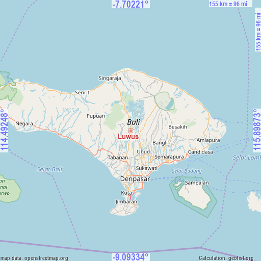
Luwus GPS coordinates[2]
8° 23' 54.24" South, 115° 11' 44.16" East
| Map corner | latitude | longitude |
|---|---|---|
| Upper-left | -7.70221°, | 114.49248° |
| Center: | -8.3984°, | 115.1956° |
| Lower-right: | -9.09334°, | 115.89873° |
| Map W x H: | 154.7×154.7 km | = 96.1×96.1mi |
| max Lat: | 5.88969° ⇑80.3% North |
| Luwus: | -8.3984° |
| min Lat: | ⇓19.7% South -10.934° |
| min Long | Luwus | max Long |
| 95.1345° | 115.1956° | 140.9419° |
| W 72.5%⇐ | ⇒27.5% E |
Elevation
Elevation of Luwus is 497 m = 1631 ft, and this is 267.3 m = 877 ft above average elevation for this country.
| Max E: |
3185 m = 10449 ft | 16.2% |
| Luwus | 497 m 1631 ft | |
| Avg. | 229.7 m = 754 ft | |
Min E: |
-1 m = -3 ft | 83.8% |
See also: Indonesia elevation on elevation.city.
Geographical zone
Luwus is located in South Torrid zone (between Equator and Tropic of Capricorn). Distance of Equator is 933.8 km =580.2 mi to North.| Distance of | km | miles | from Luwus |
|---|---|---|---|
| Equator | 933.8 | 580.2 | to North |
| Tropic Capricorn | 1672.1 | 1039 | to South |
| Antarctic Circle | 6467.4 | 4018.7 | to South |
| South Pole | 9073.2 | 5637.8 | to South |


Nearby cities:
15 places around Luwus: (largest is in red/bold)
• Banjar Angseri
5.7 km =3.5 mi,  322°
322°
• Banjar Apuan
3.8 km =2.4 mi,  329°
329°
• Banjar Buahan
4.5 km =2.8 mi,  84°
84°
• Banjar Senganan Kangin
5 km =3.1 mi,  311°
311°
• Beaung Tengah
4.6 km =2.9 mi,  235°
235°
• Empalan
4.9 km =3 mi,  274°
274°
• Pangsan
3.3 km =2.1 mi,  122°
122°
• Payangan Tengah
5.2 km =3.2 mi,  216°
216°
• Penebel
6 km =3.7 mi,  246°
246°
• Peneng
2.1 km =1.3 mi,  355°
355°
• Pergan
3.1 km =1.9 mi,  181°
181°
• Petang
2.6 km =1.6 mi, 84°
• Petiga
4.6 km =2.9 mi,  205°
205°
• Tua
2.2 km =1.4 mi,  228°
228°
• Tuka
3.8 km =2.4 mi, 175°
Sources, notices
• [Note1] Compared only with cities in Indonesia existing in our database
• [Src1] Map data: © OpenStreetMap contributors (CC-BY-SA)
• [Src2] Other city data from geonames.org with taken over terms of usage.
• [Src3] Geographical zone / Annual Mean Temperature by Robert A. Rohde @ Wikipedia
