Oja geodata
Oja (East Nusa Tenggara) is a seat of a fourth-order administrative division; located in Indonesia in Asia/Makassar (GMT+8) time zone. In our database, there are 407 cities with bigger population. Compared to other cities in Indonesia, 89.1% of cities are located further ↑North; 86.6% of cities are located further ←West and 91.8% of cities have lower elevation than Oja. Note1


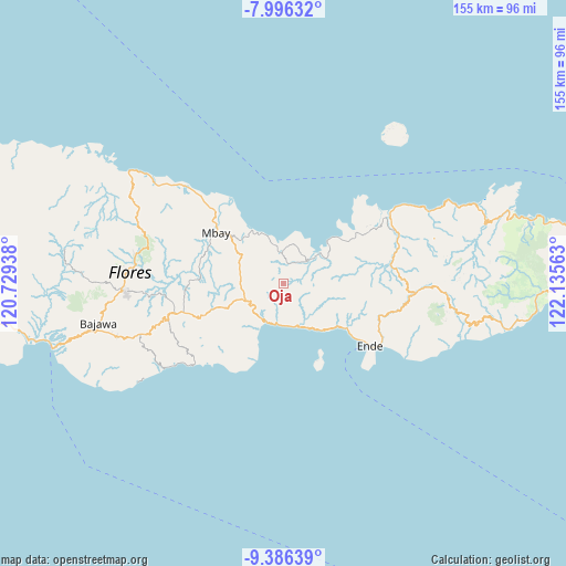
Oja GPS coordinates[2]
8° 41' 31.2" South, 121° 25' 57" East
| Map corner | latitude | longitude |
|---|---|---|
| Upper-left | -7.99632°, | 120.72938° |
| Center: | -8.692°, | 121.4325° |
| Lower-right: | -9.38639°, | 122.13563° |
| Map W x H: | 154.6×154.6 km | = 96.1×96.1mi |
| max Lat: | 5.88969° ⇑89.1% North |
| Oja: | -8.692° |
| min Lat: | ⇓10.9% South -10.934° |
| min Long | Oja | max Long |
| 95.1345° | 121.4325° | 140.9419° |
| W 86.6%⇐ | ⇒13.4% E |
Elevation
Elevation of Oja is 703 m = 2306 ft, and this is 473.3 m = 1553 ft above average elevation for this country.
| Max E: |
3185 m = 10449 ft | 8.2% |
| Oja | 703 m 2306 ft | |
| Avg. | 229.7 m = 754 ft | |
Min E: |
-1 m = -3 ft | 91.8% |
See also: Indonesia elevation on elevation.city.
Geographical zone
Oja is located in South Torrid zone (between Equator and Tropic of Capricorn). Distance of Equator is 966.5 km =600.6 mi to North.| Distance of | km | miles | from Oja |
|---|---|---|---|
| Equator | 966.5 | 600.6 | to North |
| Tropic Capricorn | 1639.5 | 1018.7 | to South |
| Antarctic Circle | 6434.7 | 3998.3 | to South |
| South Pole | 9040.6 | 5617.6 | to South |


Nearby cities:
15 places around Oja: (largest is in red/bold)
• Aegela
11.4 km =7.1 mi,  246°
246°
• Arwea
7.8 km =4.8 mi,  130°
130°
• Boanio
13.4 km =8.3 mi,  296°
296°
• Doma
11.5 km =7.1 mi,  274°
274°
• Kamubheka
7 km =4.3 mi,  62°
62°
• Kuekobo
5.1 km =3.2 mi,  238°
238°
• Maukaro
13.3 km =8.3 mi,  49°
49°
• Maunggora
15.4 km =9.6 mi,  144°
144°
• Nangapanda
11.9 km =7.4 mi,  160°
160°
• Nangaroro
11.5 km =7.1 mi,  202°
202°
• Numba
16.4 km =10.2 mi, 140°
• Puukau
3.7 km =2.3 mi,  185°
185°
• Tibakisa
14.9 km =9.3 mi, 249°
• Wakaseko
7.3 km =4.5 mi,  34°
34°
• Watuapi
9 km =5.6 mi,  351°
351°
Sources, notices
• [Note1] Compared only with cities in Indonesia existing in our database
• [Src1] Map data: © OpenStreetMap contributors (CC-BY-SA)
• [Src2] Other city data from geonames.org with taken over terms of usage.
• [Src3] Geographical zone / Annual Mean Temperature by Robert A. Rohde @ Wikipedia
