Rejoagung Satu geodata
Rejoagung Satu (East Java) is a seat of a fourth-order administrative division; located in Indonesia in Asia/Jakarta (GMT+7) time zone. In our database, there are 407 cities with bigger population. Compared to other cities in Indonesia, 79.7% of cities are located further ↑North; 69% of cities are located further ←West and 64.5% of cities have higher elevation than Rejoagung Satu. Note1


Rejoagung Satu GPS coordinates[2]
8° 22' 41.16" South, 114° 18' 36.72" East
| Map corner | latitude | longitude |
|---|---|---|
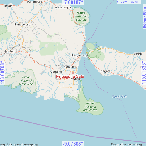
| Upper-left | -7.68187°, | 113.60708° |
| Center: | -8.3781°, | 114.3102° |
| Lower-right: | -9.07308°, | 115.01333° |
| Map W x H: | 154.7×154.7 km | = 96.1×96.1mi |
| max Lat: | 5.88969° ⇑79.7% North |
| Rejoagung Satu: | -8.3781° |
| min Lat: | ⇓20.3% South -10.934° |
| min Long | Rejoagung Satu | max Long |
| 95.1345° | 114.3102° | 140.9419° |
| W 69%⇐ | ⇒31% E |
Elevation
Elevation of Rejoagung Satu is 44 m = 144 ft, and this is 185.7 m = 609 ft below average elevation for this country.
| Max E: |
3185 m = 10449 ft | 64.5% |
| Avg. | 229.7 m = 754 ft | |
| Rejoagung Satu | 44 m = 144 ft | |
Min E: |
-1 m = -3 ft | 35.5% |
See also: Indonesia elevation on elevation.city.
Geographical zone
Rejoagung Satu is located in South Torrid zone (between Equator and Tropic of Capricorn). Distance of Equator is 931.6 km =578.9 mi to North.| Distance of | km | miles | from Rejoagung Satu |
|---|---|---|---|
| Equator | 931.6 | 578.9 | to North |
| Tropic Capricorn | 1674.4 | 1040.4 | to South |
| Antarctic Circle | 6469.6 | 4020 | to South |
| South Pole | 9075.5 | 5639.3 | to South |


Nearby cities:
15 places around Rejoagung Satu: (largest is in red/bold)
• Bagorejo
2.1 km =1.3 mi,  197°
197°
• Curahpacul Satu
9.1 km =5.7 mi,  194°
194°
• Karanglo
3.6 km =2.2 mi,  258°
258°
• Kedungrejo
7 km =4.3 mi,  170°
170°
• Kedungwringin Satu
8.8 km =5.5 mi,  162°
162°
• Krajan
8.5 km =5.3 mi,  301°
301°
• Kumendung Satu
2.5 km =1.6 mi,  103°
103°
• Melikkrajan
9.6 km =6 mi,  290°
290°
• Muncar
6.6 km =4.1 mi, 157°
• Pasinan Barat
10.7 km =6.6 mi,  311°
311°
• Payaman
7.1 km =4.4 mi, 290°
• Semalang
9.9 km =6.2 mi,  277°
277°
• Srono
5.4 km =3.4 mi,  243°
243°
• Sumberan
5.2 km =3.2 mi, 241°
• Sumbersewu
3.2 km =2 mi,  144°
144°
Sources, notices
• [Note1] Compared only with cities in Indonesia existing in our database
• [Src1] Map data: © OpenStreetMap contributors (CC-BY-SA)
• [Src2] Other city data from geonames.org with taken over terms of usage.
• [Src3] Geographical zone / Annual Mean Temperature by Robert A. Rohde @ Wikipedia
