Riung geodata
Riung (East Nusa Tenggara) is a seat of a third-order administrative division; located in Indonesia in Asia/Makassar (GMT+8) time zone. In our database, there are 407 cities with bigger population. Compared to other cities in Indonesia, 80.9% of cities are located further ↑North; 85.6% of cities are located further ←West and 79.9% of cities have higher elevation than Riung. Note1


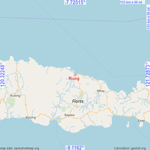
Riung GPS coordinates[2]
8° 25' 16.68" South, 121° 1' 32.16" East
| Map corner | latitude | longitude |
|---|---|---|
| Upper-left | -7.72515°, | 120.32248° |
| Center: | -8.4213°, | 121.0256° |
| Lower-right: | -9.1162°, | 121.72873° |
| Map W x H: | 154.7×154.7 km | = 96.1×96.1mi |
| max Lat: | 5.88969° ⇑80.9% North |
| Riung: | -8.4213° |
| min Lat: | ⇓19.1% South -10.934° |
| min Long | Riung | max Long |
| 95.1345° | 121.0256° | 140.9419° |
| W 85.6%⇐ | ⇒14.4% E |
Elevation
Elevation of Riung is 19 m = 62 ft, and this is 210.7 m = 691 ft below average elevation for this country.
| Max E: |
3185 m = 10449 ft | 79.9% |
| Avg. | 229.7 m = 754 ft | |
| Riung | 19 m = 62 ft | |
Min E: |
-1 m = -3 ft | 20.1% |
See also: Indonesia elevation on elevation.city.
Geographical zone
Riung is located in South Torrid zone (between Equator and Tropic of Capricorn). Distance of Equator is 936.4 km =581.9 mi to North.| Distance of | km | miles | from Riung |
|---|---|---|---|
| Equator | 936.4 | 581.9 | to North |
| Tropic Capricorn | 1669.6 | 1037.4 | to South |
| Antarctic Circle | 6464.8 | 4017 | to South |
| South Pole | 9070.7 | 5636.3 | to South |


Nearby cities:
15 places around Riung: (largest is in red/bold)
• Baobe
29 km =18 mi,  127°
127°
• Golokutu
0.7 km =0.4 mi,  172°
172°
• Kembo
16.2 km =10.1 mi,  279°
279°
• Lengkorandang
27.8 km =17.3 mi,  287°
287°
• Malabai
20.8 km =12.9 mi,  138°
138°
• Malapaubhara
27.3 km =17 mi,  156°
156°
• Marolidhong
6.5 km =4 mi,  175°
175°
• Mbarungkeli
3.7 km =2.3 mi,  299°
299°
• Nanganumba
22.3 km =13.9 mi,  103°
103°
• Nila Dua
29.6 km =18.4 mi,  109°
109°
• Punsu
0.2 km =0.1 mi,  7°
7°
• Tungguwaneng
12.5 km =7.8 mi, 102°
• Waepana
30.2 km =18.8 mi, 177°
• Wate
11.2 km =7 mi,  219°
219°
• Wewoloe
28.5 km =17.7 mi,  115°
115°
Sources, notices
• [Note1] Compared only with cities in Indonesia existing in our database
• [Src1] Map data: © OpenStreetMap contributors (CC-BY-SA)
• [Src2] Other city data from geonames.org with taken over terms of usage.
• [Src3] Geographical zone / Annual Mean Temperature by Robert A. Rohde @ Wikipedia
