Cengkok geodata
Cengkok (East Java) is a seat of a fourth-order administrative division; located in Indonesia in Asia/Jakarta (GMT+7) time zone. In our database, there are 407 cities with bigger population. Compared to other cities in Indonesia, 73.9% of cities are located further ↑North; 60% of cities are located further ←West and 66.4% of cities have higher elevation than Cengkok. Note1


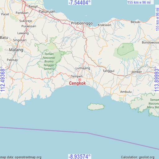
Cengkok GPS coordinates[2]
8° 14' 25.8" South, 113° 11' 48.48" East
| Map corner | latitude | longitude |
|---|---|---|
| Upper-left | -7.54404°, | 112.49368° |
| Center: | -8.2405°, | 113.1968° |
| Lower-right: | -8.93574°, | 113.89993° |
| Map W x H: | 154.7×154.7 km | = 96.1×96.1mi |
| max Lat: | 5.88969° ⇑73.9% North |
| Cengkok: | -8.2405° |
| min Lat: | ⇓26.1% South -10.934° |
| min Long | Cengkok | max Long |
| 95.1345° | 113.1968° | 140.9419° |
| W 60%⇐ | ⇒40% E |
Elevation
Elevation of Cengkok is 39 m = 128 ft, and this is 190.7 m = 626 ft below average elevation for this country.
| Max E: |
3185 m = 10449 ft | 66.4% |
| Avg. | 229.7 m = 754 ft | |
| Cengkok | 39 m = 128 ft | |
Min E: |
-1 m = -3 ft | 33.6% |
See also: Indonesia elevation on elevation.city.
Geographical zone
Cengkok is located in South Torrid zone (between Equator and Tropic of Capricorn). Distance of Equator is 916.3 km =569.4 mi to North.| Distance of | km | miles | from Cengkok |
|---|---|---|---|
| Equator | 916.3 | 569.4 | to North |
| Tropic Capricorn | 1689.7 | 1049.9 | to South |
| Antarctic Circle | 6484.9 | 4029.5 | to South |
| South Pole | 9090.8 | 5648.8 | to South |


Nearby cities:
15 places around Cengkok: (largest is in red/bold)
• Gogosan
6.2 km =3.9 mi,  76°
76°
• Jatiarum
2.8 km =1.7 mi,  98°
98°
• Karangtengah
2 km =1.2 mi,  259°
259°
• Kebonan
4.4 km =2.7 mi,  52°
52°
• Kebonsari
4.4 km =2.7 mi,  318°
318°
• Ketangi
3.3 km =2.1 mi, 54°
• Krajan Dua
5.8 km =3.6 mi,  266°
266°
• Krajan Tengah
2.9 km =1.8 mi,  356°
356°
• Mentosari
2.8 km =1.7 mi,  36°
36°
• Mujur Satu
4.4 km =2.7 mi,  302°
302°
• Pandean
2.4 km =1.5 mi,  60°
60°
• Recobanteng
5.2 km =3.2 mi,  25°
25°
• Sukolilo
4.7 km =2.9 mi,  66°
66°
• Sumberwongso
3.9 km =2.4 mi,  127°
127°
• Tempeh Tengah
4.5 km =2.8 mi,  329°
329°
Sources, notices
• [Note1] Compared only with cities in Indonesia existing in our database
• [Src1] Map data: © OpenStreetMap contributors (CC-BY-SA)
• [Src2] Other city data from geonames.org with taken over terms of usage.
• [Src3] Geographical zone / Annual Mean Temperature by Robert A. Rohde @ Wikipedia
