Blong Daye geodata
Blong Daye (West Nusa Tenggara) is a seat of a fourth-order administrative division; located in Indonesia in Asia/Makassar (GMT+8) time zone. In our database, there are 407 cities with bigger population. Compared to other cities in Indonesia, 89.1% of cities are located further ↑North; 76.4% of cities are located further ←West and 50% of cities have lower elevation than Blong Daye. Note1


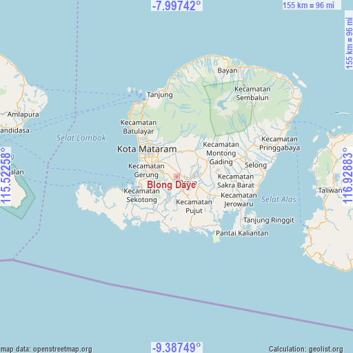
Blong Daye GPS coordinates[2]
8° 41' 35.16" South, 116° 13' 32.52" East
| Map corner | latitude | longitude |
|---|---|---|
| Upper-left | -7.99742°, | 115.52258° |
| Center: | -8.6931°, | 116.2257° |
| Lower-right: | -9.38749°, | 116.92883° |
| Map W x H: | 154.6×154.6 km | = 96.1×96.1mi |
| max Lat: | 5.88969° ⇑89.1% North |
| Blong Daye: | -8.6931° |
| min Lat: | ⇓10.9% South -10.934° |
| min Long | Blong Daye | max Long |
| 95.1345° | 116.2257° | 140.9419° |
| W 76.4%⇐ | ⇒23.6% E |
Elevation
Elevation of Blong Daye is 102 m = 335 ft, and this is 127.7 m = 419 ft below average elevation for this country.
| Max E: |
3185 m = 10449 ft | 50% |
| Avg. | 229.7 m = 754 ft | |
| Blong Daye | 102 m = 335 ft | |
Min E: |
-1 m = -3 ft | 50% |
See also: Indonesia elevation on elevation.city.
Geographical zone
Blong Daye is located in South Torrid zone (between Equator and Tropic of Capricorn). Distance of Equator is 966.6 km =600.6 mi to North.| Distance of | km | miles | from Blong Daye |
|---|---|---|---|
| Equator | 966.6 | 600.6 | to North |
| Tropic Capricorn | 1639.3 | 1018.6 | to South |
| Antarctic Circle | 6434.6 | 3998.3 | to South |
| South Pole | 9040.5 | 5617.5 | to South |


Nearby cities:
15 places around Blong Daye: (largest is in red/bold)
• Ampanlolat
4.2 km =2.6 mi,  225°
225°
• Bangekdewa
7.1 km =4.4 mi,  211°
211°
• Barejulat
4.8 km =3 mi,  37°
37°
• Batutulis
1.3 km =0.8 mi,  279°
279°
• Karang Daye
6 km =3.7 mi,  163°
163°
• Karangdalam
5.4 km =3.4 mi, 159°
• Pagutan
9.7 km =6 mi, 41°
• Pendaleman
1.9 km =1.2 mi,  59°
59°
• Penunjak
6 km =3.7 mi, 164°
• Permas
5.3 km =3.3 mi,  201°
201°
• Praya
5.1 km =3.2 mi,  105°
105°
• Ranggagata
5.6 km =3.5 mi, 234°
• Semayan
7 km =4.3 mi, 114°
• Sintung Timur
9.3 km =5.8 mi,  357°
357°
• Tanakbeak Daye
9.9 km =6.2 mi,  345°
345°
Sources, notices
• [Note1] Compared only with cities in Indonesia existing in our database
• [Src1] Map data: © OpenStreetMap contributors (CC-BY-SA)
• [Src2] Other city data from geonames.org with taken over terms of usage.
• [Src3] Geographical zone / Annual Mean Temperature by Robert A. Rohde @ Wikipedia
