Rerawere geodata
Rerawere (East Nusa Tenggara) is a seat of a fourth-order administrative division; located in Indonesia in Asia/Makassar (GMT+8) time zone. In our database, there are 407 cities with bigger population. Compared to other cities in Indonesia, 86.3% of cities are located further ↑North; 86.7% of cities are located further ←West and 84.2% of cities have higher elevation than Rerawere. Note1


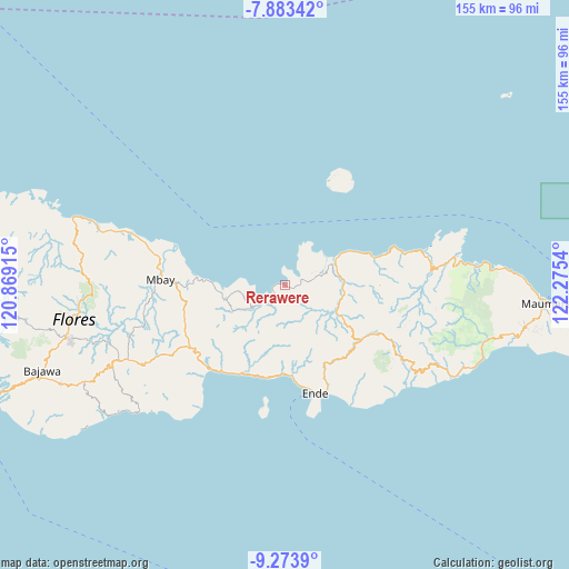
Rerawere GPS coordinates[2]
8° 34' 45.48" South, 121° 34' 20.172" East
| Map corner | latitude | longitude |
|---|---|---|
| Upper-left | -7.88342°, | 120.86915° |
| Center: | -8.5793°, | 121.57227° |
| Lower-right: | -9.2739°, | 122.2754° |
| Map W x H: | 154.6×154.6 km | = 96.1×96.1mi |
| max Lat: | 5.88969° ⇑86.3% North |
| Rerawere: | -8.5793° |
| min Lat: | ⇓13.7% South -10.934° |
| min Long | Rerawere | max Long |
| 95.1345° | 121.57227° | 140.9419° |
| W 86.7%⇐ | ⇒13.3% E |
Elevation
Elevation of Rerawere is 15 m = 49 ft, and this is 214.7 m = 704 ft below average elevation for this country.
| Max E: |
3185 m = 10449 ft | 84.2% |
| Avg. | 229.7 m = 754 ft | |
| Rerawere | 15 m = 49 ft | |
Min E: |
-1 m = -3 ft | 15.8% |
See also: Indonesia elevation on elevation.city.
Geographical zone
Rerawere is located in South Torrid zone (between Equator and Tropic of Capricorn). Distance of Equator is 953.9 km =592.7 mi to North.| Distance of | km | miles | from Rerawere |
|---|---|---|---|
| Equator | 953.9 | 592.7 | to North |
| Tropic Capricorn | 1652 | 1026.5 | to South |
| Antarctic Circle | 6447.2 | 4006.1 | to South |
| South Pole | 9053.1 | 5625.3 | to South |


Nearby cities:
15 places around Rerawere: (largest is in red/bold)
• Aelande
16.9 km =10.5 mi,  96°
96°
• Arwea
20 km =12.4 mi,  208°
208°
• Boafeo
13.7 km =8.5 mi,  154°
154°
• Boujawa
18.4 km =11.4 mi,  158°
158°
• Kamubheka
13.1 km =8.1 mi,  224°
224°
• Londe
17.4 km =10.8 mi, 99°
• Maukaro
6.5 km =4 mi,  232°
232°
• Mbani
14.9 km =9.3 mi,  142°
142°
• Mukusaki
5.1 km =3.2 mi,  72°
72°
• Oja
19.8 km =12.3 mi, 230°
• Tendaleo
16 km =9.9 mi,  118°
118°
• Wakaseko
12.9 km =8 mi,  239°
239°
• Watuapi
17.1 km =10.6 mi,  257°
257°
• Welamosa
16.3 km =10.1 mi, 100°
• Wolomuku
18.7 km =11.6 mi, 98°
Sources, notices
• [Note1] Compared only with cities in Indonesia existing in our database
• [Src1] Map data: © OpenStreetMap contributors (CC-BY-SA)
• [Src2] Other city data from geonames.org with taken over terms of usage.
• [Src3] Geographical zone / Annual Mean Temperature by Robert A. Rohde @ Wikipedia
