Wunat geodata
Wunat (East Nusa Tenggara) is a seat of a fourth-order administrative division; located in Indonesia in Asia/Makassar (GMT+8) time zone. In our database, there are 407 cities with bigger population. Compared to other cities in Indonesia, 84.4% of cities are located further ↑North; 83.3% of cities are located further ←West and 90.9% of cities have lower elevation than Wunat. Note1


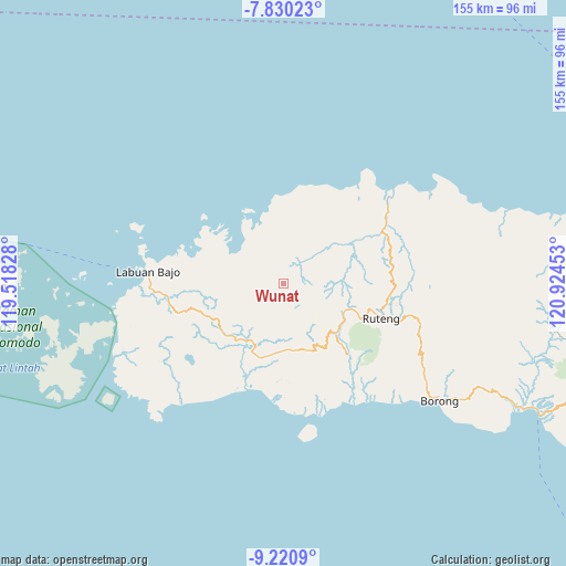
Wunat GPS coordinates[2]
8° 31' 34.32" South, 120° 13' 17.04" East
| Map corner | latitude | longitude |
|---|---|---|
| Upper-left | -7.83023°, | 119.51828° |
| Center: | -8.5262°, | 120.2214° |
| Lower-right: | -9.2209°, | 120.92453° |
| Map W x H: | 154.6×154.6 km | = 96.1×96.1mi |
| max Lat: | 5.88969° ⇑84.4% North |
| Wunat: | -8.5262° |
| min Lat: | ⇓15.6% South -10.934° |
| min Long | Wunat | max Long |
| 95.1345° | 120.2214° | 140.9419° |
| W 83.3%⇐ | ⇒16.7% E |
Elevation
Elevation of Wunat is 674 m = 2211 ft, and this is 444.3 m = 1458 ft above average elevation for this country.
| Max E: |
3185 m = 10449 ft | 9.1% |
| Wunat | 674 m 2211 ft | |
| Avg. | 229.7 m = 754 ft | |
Min E: |
-1 m = -3 ft | 90.9% |
See also: Indonesia elevation on elevation.city.
Geographical zone
Wunat is located in South Torrid zone (between Equator and Tropic of Capricorn). Distance of Equator is 948 km =589.1 mi to North.| Distance of | km | miles | from Wunat |
|---|---|---|---|
| Equator | 948 | 589.1 | to North |
| Tropic Capricorn | 1657.9 | 1030.2 | to South |
| Antarctic Circle | 6453.1 | 4009.8 | to South |
| South Pole | 9059 | 5629 | to South |


Nearby cities:
15 places around Wunat: (largest is in red/bold)
• Betong
19 km =11.8 mi,  273°
273°
• Handeng
9.5 km =5.9 mi, 267°
• Jeong
6.6 km =4.1 mi,  171°
171°
• Lando
16 km =9.9 mi,  281°
281°
• Mberheleng
17.1 km =10.6 mi, 275°
• Noa
2.4 km =1.5 mi,  258°
258°
• Pacar
5.4 km =3.4 mi,  335°
335°
• Pau
10.1 km =6.3 mi, 341°
• Rawuk
4.4 km =2.7 mi,  157°
157°
• Rego
11.7 km =7.3 mi,  19°
19°
• Sasa
10.7 km =6.6 mi, 335°
• Semang
5.8 km =3.6 mi,  182°
182°
• Terang
17.5 km =10.9 mi,  296°
296°
• Tondongraja
19 km =11.8 mi,  250°
250°
• Waepitak
4.1 km =2.5 mi,  130°
130°
Sources, notices
• [Note1] Compared only with cities in Indonesia existing in our database
• [Src1] Map data: © OpenStreetMap contributors (CC-BY-SA)
• [Src2] Other city data from geonames.org with taken over terms of usage.
• [Src3] Geographical zone / Annual Mean Temperature by Robert A. Rohde @ Wikipedia
