Mberheleng geodata
Mberheleng (East Nusa Tenggara) is a seat of a fourth-order administrative division; located in Indonesia in Asia/Makassar (GMT+8) time zone. In our database, there are 407 cities with bigger population. Compared to other cities in Indonesia, 83.9% of cities are located further ↑North; 82.9% of cities are located further ←West and 64.8% of cities have higher elevation than Mberheleng. Note1


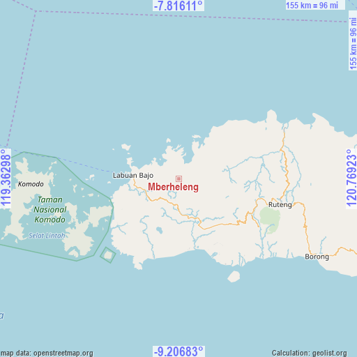
Mberheleng GPS coordinates[2]
8° 30' 43.56" South, 120° 3' 57.96" East
| Map corner | latitude | longitude |
|---|---|---|
| Upper-left | -7.81611°, | 119.36298° |
| Center: | -8.5121°, | 120.0661° |
| Lower-right: | -9.20683°, | 120.76923° |
| Map W x H: | 154.6×154.6 km | = 96.1×96.1mi |
| max Lat: | 5.88969° ⇑83.9% North |
| Mberheleng: | -8.5121° |
| min Lat: | ⇓16.1% South -10.934° |
| min Long | Mberheleng | max Long |
| 95.1345° | 120.0661° | 140.9419° |
| W 82.9%⇐ | ⇒17.1% E |
Elevation
Elevation of Mberheleng is 43 m = 141 ft, and this is 186.7 m = 613 ft below average elevation for this country.
| Max E: |
3185 m = 10449 ft | 64.8% |
| Avg. | 229.7 m = 754 ft | |
| Mberheleng | 43 m = 141 ft | |
Min E: |
-1 m = -3 ft | 35.2% |
See also: Indonesia elevation on elevation.city.
Geographical zone
Mberheleng is located in South Torrid zone (between Equator and Tropic of Capricorn). Distance of Equator is 946.5 km =588.1 mi to North.| Distance of | km | miles | from Mberheleng |
|---|---|---|---|
| Equator | 946.5 | 588.1 | to North |
| Tropic Capricorn | 1659.5 | 1031.2 | to South |
| Antarctic Circle | 6454.7 | 4010.8 | to South |
| South Pole | 9060.6 | 5630 | to South |


Nearby cities:
15 places around Mberheleng: (largest is in red/bold)
• Bambor
11.2 km =7 mi,  183°
183°
• Betong
2 km =1.2 mi,  257°
257°
• Bolengpulau
11.4 km =7.1 mi,  316°
316°
• Golondalas
10.5 km =6.5 mi,  210°
210°
• Handeng
7.9 km =4.9 mi,  104°
104°
• Lando
2.2 km =1.4 mi,  39°
39°
• Melo
14.9 km =9.3 mi,  230°
230°
• Ndewel
8.2 km =5.1 mi,  193°
193°
• Noa
14.9 km =9.3 mi, 97°
• Ranggawatu
11.4 km =7.1 mi, 192°
• Rungkam
9.4 km =5.8 mi,  297°
297°
• Terang
6.4 km =4 mi,  13°
13°
• Tohong
8.5 km =5.3 mi, 233°
• Tondongraja
8 km =5 mi, 186°
• Wangkung
6.3 km =3.9 mi,  265°
265°
Sources, notices
• [Note1] Compared only with cities in Indonesia existing in our database
• [Src1] Map data: © OpenStreetMap contributors (CC-BY-SA)
• [Src2] Other city data from geonames.org with taken over terms of usage.
• [Src3] Geographical zone / Annual Mean Temperature by Robert A. Rohde @ Wikipedia
