Lando geodata
Lando (East Nusa Tenggara) is a seat of a fourth-order administrative division; located in Indonesia in Asia/Makassar (GMT+8) time zone. In our database, there are 407 cities with bigger population. Compared to other cities in Indonesia, 83.3% of cities are located further ↑North; 83% of cities are located further ←West and 74.9% of cities have higher elevation than Lando. Note1


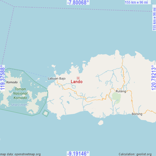
Lando GPS coordinates[2]
8° 29' 48.12" South, 120° 4' 44.4" East
| Map corner | latitude | longitude |
|---|---|---|
| Upper-left | -7.80068°, | 119.37588° |
| Center: | -8.4967°, | 120.079° |
| Lower-right: | -9.19146°, | 120.78213° |
| Map W x H: | 154.6×154.6 km | = 96.1×96.1mi |
| max Lat: | 5.88969° ⇑83.3% North |
| Lando: | -8.4967° |
| min Lat: | ⇓16.7% South -10.934° |
| min Long | Lando | max Long |
| 95.1345° | 120.079° | 140.9419° |
| W 83%⇐ | ⇒17% E |
Elevation
Elevation of Lando is 25 m = 82 ft, and this is 204.7 m = 672 ft below average elevation for this country.
| Max E: |
3185 m = 10449 ft | 74.9% |
| Avg. | 229.7 m = 754 ft | |
| Lando | 25 m = 82 ft | |
Min E: |
-1 m = -3 ft | 25.1% |
See also: Indonesia elevation on elevation.city.
Geographical zone
Lando is located in South Torrid zone (between Equator and Tropic of Capricorn). Distance of Equator is 944.7 km =587 mi to North.| Distance of | km | miles | from Lando |
|---|---|---|---|
| Equator | 944.7 | 587 | to North |
| Tropic Capricorn | 1661.2 | 1032.2 | to South |
| Antarctic Circle | 6456.4 | 4011.8 | to South |
| South Pole | 9062.3 | 5631.1 | to South |


Nearby cities:
15 places around Lando: (largest is in red/bold)
• Bambor
13.1 km =8.1 mi,  189°
189°
• Betong
4 km =2.5 mi,  237°
237°
• Bolengpulau
11.3 km =7 mi,  304°
304°
• Golondalas
12.7 km =7.9 mi,  211°
211°
• Handeng
7.2 km =4.5 mi,  120°
120°
• Mberheleng
2.2 km =1.4 mi,  219°
219°
• Ndewel
10.3 km =6.4 mi,  199°
199°
• Pacar
13.5 km =8.4 mi,  83°
83°
• Ranggawatu
13.4 km =8.3 mi, 196°
• Rungkam
10.2 km =6.3 mi,  284°
284°
• Sasa
12.9 km =8 mi,  60°
60°
• Terang
4.5 km =2.8 mi,  0°
0°
• Tohong
10.7 km =6.6 mi,  231°
231°
• Tondongraja
9.9 km =6.2 mi, 193°
• Wangkung
8 km =5 mi,  254°
254°
Sources, notices
• [Note1] Compared only with cities in Indonesia existing in our database
• [Src1] Map data: © OpenStreetMap contributors (CC-BY-SA)
• [Src2] Other city data from geonames.org with taken over terms of usage.
• [Src3] Geographical zone / Annual Mean Temperature by Robert A. Rohde @ Wikipedia
