Handeng geodata
Handeng (East Nusa Tenggara) is a seat of a fourth-order administrative division; located in Indonesia in Asia/Makassar (GMT+8) time zone. In our database, there are 407 cities with bigger population. Compared to other cities in Indonesia, 84.5% of cities are located further ↑North; 83.1% of cities are located further ←West and 77.2% of cities have lower elevation than Handeng. Note1


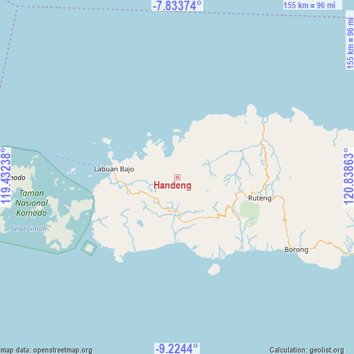
Handeng GPS coordinates[2]
8° 31' 46.92" South, 120° 8' 7.8" East
| Map corner | latitude | longitude |
|---|---|---|
| Upper-left | -7.83374°, | 119.43238° |
| Center: | -8.5297°, | 120.1355° |
| Lower-right: | -9.2244°, | 120.83863° |
| Map W x H: | 154.6×154.6 km | = 96.1×96.1mi |
| max Lat: | 5.88969° ⇑84.5% North |
| Handeng: | -8.5297° |
| min Lat: | ⇓15.5% South -10.934° |
| min Long | Handeng | max Long |
| 95.1345° | 120.1355° | 140.9419° |
| W 83.1%⇐ | ⇒16.9% E |
Elevation
Elevation of Handeng is 387 m = 1270 ft, and this is 157.3 m = 516 ft above average elevation for this country.
| Max E: |
3185 m = 10449 ft | 22.8% |
| Handeng | 387 m 1270 ft | |
| Avg. | 229.7 m = 754 ft | |
Min E: |
-1 m = -3 ft | 77.2% |
See also: Indonesia elevation on elevation.city.
Geographical zone
Handeng is located in South Torrid zone (between Equator and Tropic of Capricorn). Distance of Equator is 948.4 km =589.3 mi to North.| Distance of | km | miles | from Handeng |
|---|---|---|---|
| Equator | 948.4 | 589.3 | to North |
| Tropic Capricorn | 1657.5 | 1029.9 | to South |
| Antarctic Circle | 6452.8 | 4009.6 | to South |
| South Pole | 9058.6 | 5628.8 | to South |


Nearby cities:
15 places around Handeng: (largest is in red/bold)
• Bambor
12.4 km =7.7 mi,  222°
222°
• Betong
9.7 km =6 mi,  279°
279°
• Jeong
12.1 km =7.5 mi,  120°
120°
• Lando
7.2 km =4.5 mi,  300°
300°
• Mberheleng
7.9 km =4.9 mi, 284°
• Ndewel
11.3 km =7 mi,  237°
237°
• Noa
7.1 km =4.4 mi,  90°
90°
• Pacar
8.9 km =5.5 mi,  53°
53°
• Pau
11.8 km =7.3 mi,  32°
32°
• Rawuk
11.7 km =7.3 mi,  108°
108°
• Sasa
11.3 km =7 mi, 26°
• Semang
10.6 km =6.6 mi, 120°
• Terang
10.2 km =6.3 mi,  322°
322°
• Tondongraja
10.4 km =6.5 mi,  234°
234°
• Wunat
9.5 km =5.9 mi, 87°
Sources, notices
• [Note1] Compared only with cities in Indonesia existing in our database
• [Src1] Map data: © OpenStreetMap contributors (CC-BY-SA)
• [Src2] Other city data from geonames.org with taken over terms of usage.
• [Src3] Geographical zone / Annual Mean Temperature by Robert A. Rohde @ Wikipedia
