Natarleba geodata
Natarleba (East Nusa Tenggara) is a seat of a fourth-order administrative division; located in Indonesia in Asia/Makassar (GMT+8) time zone. In our database, there are 407 cities with bigger population. Compared to other cities in Indonesia, 84% of cities are located further ↑North; 89% of cities are located further ←West and 71.9% of cities have higher elevation than Natarleba. Note1


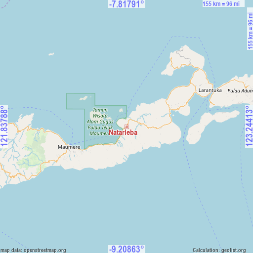
Natarleba GPS coordinates[2]
8° 30' 50.04" South, 122° 32' 27.6" East
| Map corner | latitude | longitude |
|---|---|---|
| Upper-left | -7.81791°, | 121.83788° |
| Center: | -8.5139°, | 122.541° |
| Lower-right: | -9.20863°, | 123.24413° |
| Map W x H: | 154.6×154.6 km | = 96.1×96.1mi |
| max Lat: | 5.88969° ⇑84% North |
| Natarleba: | -8.5139° |
| min Lat: | ⇓16% South -10.934° |
| min Long | Natarleba | max Long |
| 95.1345° | 122.541° | 140.9419° |
| W 89%⇐ | ⇒11% E |
Elevation
Elevation of Natarleba is 29 m = 95 ft, and this is 200.7 m = 658 ft below average elevation for this country.
| Max E: |
3185 m = 10449 ft | 71.9% |
| Avg. | 229.7 m = 754 ft | |
| Natarleba | 29 m = 95 ft | |
Min E: |
-1 m = -3 ft | 28.1% |
See also: Indonesia elevation on elevation.city.
Geographical zone
Natarleba is located in South Torrid zone (between Equator and Tropic of Capricorn). Distance of Equator is 946.7 km =588.3 mi to North.| Distance of | km | miles | from Natarleba |
|---|---|---|---|
| Equator | 946.7 | 588.3 | to North |
| Tropic Capricorn | 1659.3 | 1031 | to South |
| Antarctic Circle | 6454.5 | 4010.6 | to South |
| South Pole | 9060.4 | 5629.9 | to South |


Nearby cities:
15 places around Natarleba: (largest is in red/bold)
• Boganatar
11 km =6.8 mi,  84°
84°
• Boru
18.7 km =11.6 mi,  93°
93°
• Ewa
12.7 km =7.9 mi,  196°
196°
• Hila
9.6 km =6 mi,  124°
124°
• Koja Besar
16.3 km =10.1 mi,  280°
280°
• Nangahale
6.3 km =3.9 mi,  217°
217°
• Natargran
17.3 km =10.7 mi,  230°
230°
• Natarmage
10.3 km =6.4 mi,  164°
164°
• Nebe
5 km =3.1 mi,  26°
26°
• Palue
18.9 km =11.7 mi,  74°
74°
• Parumaan
12.6 km =7.8 mi,  301°
301°
• Sukutukang
19 km =11.8 mi, 86°
• Talibura
2.1 km =1.3 mi,  235°
235°
• Waigete
17.3 km =10.7 mi, 230°
• Wolometang
10.2 km =6.3 mi,  142°
142°
Sources, notices
• [Note1] Compared only with cities in Indonesia existing in our database
• [Src1] Map data: © OpenStreetMap contributors (CC-BY-SA)
• [Src2] Other city data from geonames.org with taken over terms of usage.
• [Src3] Geographical zone / Annual Mean Temperature by Robert A. Rohde @ Wikipedia
