Lokokrangan geodata
Lokokrangan (West Nusa Tenggara) is a seat of a third-order administrative division; located in Indonesia in Asia/Makassar (GMT+8) time zone. In our database, there are 407 cities with bigger population. Compared to other cities in Indonesia, 74.6% of cities are located further ↑North; 76.5% of cities are located further ←West and 85.2% of cities have higher elevation than Lokokrangan. Note1


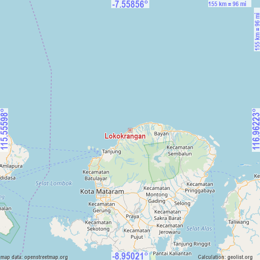
Lokokrangan GPS coordinates[2]
8° 15' 18" South, 116° 15' 32.76" East
| Map corner | latitude | longitude |
|---|---|---|
| Upper-left | -7.55856°, | 115.55598° |
| Center: | -8.255°, | 116.2591° |
| Lower-right: | -8.95021°, | 116.96223° |
| Map W x H: | 154.7×154.7 km | = 96.1×96.1mi |
| max Lat: | 5.88969° ⇑74.6% North |
| Lokokrangan: | -8.255° |
| min Lat: | ⇓25.4% South -10.934° |
| min Long | Lokokrangan | max Long |
| 95.1345° | 116.2591° | 140.9419° |
| W 76.5%⇐ | ⇒23.5% E |
Elevation
Elevation of Lokokrangan is 14 m = 46 ft, and this is 215.7 m = 708 ft below average elevation for this country.
| Max E: |
3185 m = 10449 ft | 85.2% |
| Avg. | 229.7 m = 754 ft | |
| Lokokrangan | 14 m = 46 ft | |
Min E: |
-1 m = -3 ft | 14.8% |
See also: Indonesia elevation on elevation.city.
Geographical zone
Lokokrangan is located in South Torrid zone (between Equator and Tropic of Capricorn). Distance of Equator is 917.9 km =570.4 mi to North.| Distance of | km | miles | from Lokokrangan |
|---|---|---|---|
| Equator | 917.9 | 570.4 | to North |
| Tropic Capricorn | 1688 | 1048.9 | to South |
| Antarctic Circle | 6483.3 | 4028.5 | to South |
| South Pole | 9089.2 | 5647.8 | to South |


Nearby cities:
15 places around Lokokrangan: (largest is in red/bold)
• Akarakar
9.9 km =6.2 mi,  67°
67°
• Anyar
18.5 km =11.5 mi,  81°
81°
• Bayan
18.4 km =11.4 mi,  94°
94°
• Gili Air
22.6 km =14 mi,  239°
239°
• Gili Trawangan
26.6 km =16.5 mi,  246°
246°
• Karanggedang
15.8 km =9.8 mi, 76°
• Karangsubagan
24.2 km =15 mi,  225°
225°
• Loloan
19.9 km =12.4 mi, 90°
• Pemenang
23.9 km =14.9 mi, 226°
• Prawira
17.3 km =10.7 mi, 227°
• Santong
7.6 km =4.7 mi,  156°
156°
• Tampes
5.1 km =3.2 mi,  63°
63°
• Tanahsong Daya
14.7 km =9.1 mi,  223°
223°
• Tanjung
15.9 km =9.9 mi, 225°
• Todo
15.5 km =9.6 mi,  213°
213°
Sources, notices
• [Note1] Compared only with cities in Indonesia existing in our database
• [Src1] Map data: © OpenStreetMap contributors (CC-BY-SA)
• [Src2] Other city data from geonames.org with taken over terms of usage.
• [Src3] Geographical zone / Annual Mean Temperature by Robert A. Rohde @ Wikipedia
