Tampes geodata
Tampes (West Nusa Tenggara) is a seat of a fourth-order administrative division; located in Indonesia in Asia/Makassar (GMT+8) time zone. In our database, there are 407 cities with bigger population. Compared to other cities in Indonesia, 73.5% of cities are located further ↑North; 76.7% of cities are located further ←West and 86.4% of cities have higher elevation than Tampes. Note1


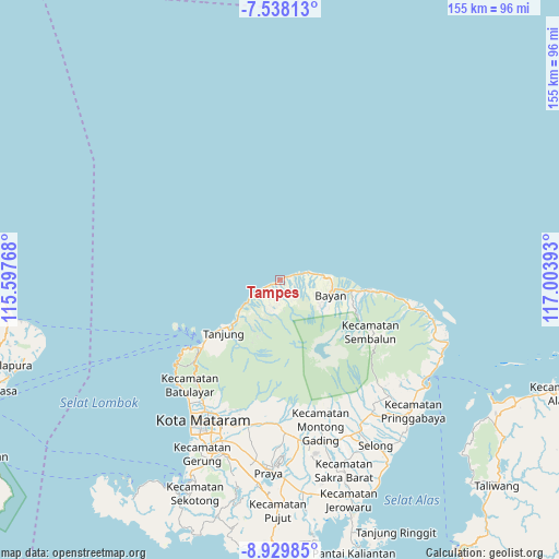
Tampes GPS coordinates[2]
8° 14' 4.56" South, 116° 18' 2.88" East
| Map corner | latitude | longitude |
|---|---|---|
| Upper-left | -7.53813°, | 115.59768° |
| Center: | -8.2346°, | 116.3008° |
| Lower-right: | -8.92985°, | 117.00393° |
| Map W x H: | 154.7×154.7 km | = 96.1×96.1mi |
| max Lat: | 5.88969° ⇑73.5% North |
| Tampes: | -8.2346° |
| min Lat: | ⇓26.5% South -10.934° |
| min Long | Tampes | max Long |
| 95.1345° | 116.3008° | 140.9419° |
| W 76.7%⇐ | ⇒23.3% E |
Elevation
Elevation of Tampes is 13 m = 43 ft, and this is 216.7 m = 711 ft below average elevation for this country.
| Max E: |
3185 m = 10449 ft | 86.4% |
| Avg. | 229.7 m = 754 ft | |
| Tampes | 13 m = 43 ft | |
Min E: |
-1 m = -3 ft | 13.6% |
See also: Indonesia elevation on elevation.city.
Geographical zone
Tampes is located in South Torrid zone (between Equator and Tropic of Capricorn). Distance of Equator is 915.6 km =568.9 mi to North.| Distance of | km | miles | from Tampes |
|---|---|---|---|
| Equator | 915.6 | 568.9 | to North |
| Tropic Capricorn | 1690.3 | 1050.3 | to South |
| Antarctic Circle | 6485.6 | 4030 | to South |
| South Pole | 9091.5 | 5649.2 | to South |


Nearby cities:
15 places around Tampes: (largest is in red/bold)
• Akarakar
4.8 km =3 mi,  72°
72°
• Anyar
13.7 km =8.5 mi,  87°
87°
• Bayan
14.2 km =8.8 mi,  105°
105°
• Gili Air
27.7 km =17.2 mi,  240°
240°
• Karanggedang
10.9 km =6.8 mi,  83°
83°
• Lelongken
23.7 km =14.7 mi, 114°
• Lokokrangan
5.1 km =3.2 mi, 243°
• Loloan
15.5 km =9.6 mi,  98°
98°
• Obelobel
27.5 km =17.1 mi, 97°
• Pemenang
28.8 km =17.9 mi,  229°
229°
• Prawira
22.3 km =13.9 mi, 230°
• Santong
9.4 km =5.8 mi,  189°
189°
• Tanahsong Daya
19.6 km =12.2 mi, 228°
• Tanjung
20.8 km =12.9 mi, 229°
• Todo
20.1 km =12.5 mi,  220°
220°
Sources, notices
• [Note1] Compared only with cities in Indonesia existing in our database
• [Src1] Map data: © OpenStreetMap contributors (CC-BY-SA)
• [Src2] Other city data from geonames.org with taken over terms of usage.
• [Src3] Geographical zone / Annual Mean Temperature by Robert A. Rohde @ Wikipedia
