Anyar geodata
Anyar (West Nusa Tenggara) is a seat of a third-order administrative division; located in Indonesia in Asia/Makassar (GMT+8) time zone. In our database, there are 407 cities with bigger population. Compared to other cities in Indonesia, 73.4% of cities are located further ↑North; 77.2% of cities are located further ←West and 71.9% of cities have higher elevation than Anyar. Note1


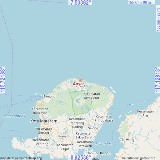
Anyar GPS coordinates[2]
8° 13' 48.36" South, 116° 25' 30" East
| Map corner | latitude | longitude |
|---|---|---|
| Upper-left | -7.53362°, | 115.72188° |
| Center: | -8.2301°, | 116.425° |
| Lower-right: | -8.92536°, | 117.12813° |
| Map W x H: | 154.7×154.7 km | = 96.1×96.1mi |
| max Lat: | 5.88969° ⇑73.4% North |
| Anyar: | -8.2301° |
| min Lat: | ⇓26.6% South -10.934° |
| min Long | Anyar | max Long |
| 95.1345° | 116.425° | 140.9419° |
| W 77.2%⇐ | ⇒22.8% E |
Elevation
Elevation of Anyar is 29 m = 95 ft, and this is 200.7 m = 658 ft below average elevation for this country.
| Max E: |
3185 m = 10449 ft | 71.9% |
| Avg. | 229.7 m = 754 ft | |
| Anyar | 29 m = 95 ft | |
Min E: |
-1 m = -3 ft | 28.1% |
See also: Indonesia elevation on elevation.city.
Geographical zone
Anyar is located in South Torrid zone (between Equator and Tropic of Capricorn). Distance of Equator is 915.1 km =568.6 mi to North.| Distance of | km | miles | from Anyar |
|---|---|---|---|
| Equator | 915.1 | 568.6 | to North |
| Tropic Capricorn | 1690.8 | 1050.6 | to South |
| Antarctic Circle | 6486.1 | 4030.3 | to South |
| South Pole | 9092 | 5649.5 | to South |


Nearby cities:
15 places around Anyar: (largest is in red/bold)
• Akarakar
9.1 km =5.7 mi,  276°
276°
• Bayan
4.3 km =2.7 mi,  179°
179°
• Belanting
23.8 km =14.8 mi,  110°
110°
• Karanggedang
3 km =1.9 mi,  285°
285°
• Lelongken
13 km =8.1 mi,  142°
142°
• Lokokrangan
18.5 km =11.5 mi,  261°
261°
• Loloan
3.3 km =2.1 mi,  151°
151°
• Montongkemong
32.3 km =20.1 mi, 153°
• Obelobel
14.2 km =8.8 mi, 106°
• Santong
18.1 km =11.2 mi,  237°
237°
• Sembalunbumbung
21.7 km =13.5 mi, 142°
• Sembalunlawang
19.1 km =11.9 mi, 141°
• Tampes
13.7 km =8.5 mi,  267°
267°
• Tanahsong Daya
31.3 km =19.4 mi, 244°
• Todo
31 km =19.3 mi, 239°
Sources, notices
• [Note1] Compared only with cities in Indonesia existing in our database
• [Src1] Map data: © OpenStreetMap contributors (CC-BY-SA)
• [Src2] Other city data from geonames.org with taken over terms of usage.
• [Src3] Geographical zone / Annual Mean Temperature by Robert A. Rohde @ Wikipedia
