Radamata geodata
Radamata (East Nusa Tenggara) is a seat of a fourth-order administrative division; located in Indonesia in Asia/Makassar (GMT+8) time zone. In our database, there are 407 cities with bigger population. Compared to other cities in Indonesia, 93.3% of cities are located further ↑North; 81.1% of cities are located further ←West and 73% of cities have lower elevation than Radamata. Note1


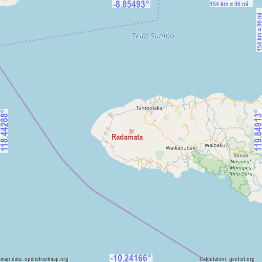
Radamata GPS coordinates[2]
9° 32' 56.4" South, 119° 8' 45.6" East
| Map corner | latitude | longitude |
|---|---|---|
| Upper-left | -8.85493°, | 118.44288° |
| Center: | -9.549°, | 119.146° |
| Lower-right: | -10.24166°, | 119.84913° |
| Map W x H: | 154.2×154.2 km | = 95.8×95.8mi |
| max Lat: | 5.88969° ⇑93.3% North |
| Radamata: | -9.549° |
| min Lat: | ⇓6.7% South -10.934° |
| min Long | Radamata | max Long |
| 95.1345° | 119.146° | 140.9419° |
| W 81.1%⇐ | ⇒18.9% E |
Elevation
Elevation of Radamata is 334 m = 1096 ft, and this is 104.3 m = 342 ft above average elevation for this country.
| Max E: |
3185 m = 10449 ft | 27% |
| Radamata | 334 m 1096 ft | |
| Avg. | 229.7 m = 754 ft | |
Min E: |
-1 m = -3 ft | 73% |
See also: Indonesia elevation on elevation.city.
Geographical zone
Radamata is located in South Torrid zone (between Equator and Tropic of Capricorn). Distance of Equator is 1061.7 km =659.7 mi to North.| Distance of | km | miles | from Radamata |
|---|---|---|---|
| Equator | 1061.7 | 659.7 | to North |
| Tropic Capricorn | 1544.2 | 959.5 | to South |
| Antarctic Circle | 6339.4 | 3939.1 | to South |
| South Pole | 8945.3 | 5558.4 | to South |


Nearby cities:
15 places around Radamata: (largest is in red/bold)
• Delo
8.9 km =5.5 mi,  124°
124°
• Hombakaripit
12.8 km =8 mi,  283°
283°
• Kalembutillu
10.8 km =6.7 mi,  96°
96°
• Kori
13 km =8.1 mi,  290°
290°
• Lokorota
9.8 km =6.1 mi,  244°
244°
• Manola
6.3 km =3.9 mi,  105°
105°
• Marokota
6.3 km =3.9 mi,  32°
32°
• Padedemanu
11.9 km =7.4 mi,  336°
336°
• Pasolapida
10.3 km =6.4 mi,  169°
169°
• Pasonobenu
2.7 km =1.7 mi,  92°
92°
• Waiholo
7.6 km =4.7 mi,  297°
297°
• Waimangura
11 km =6.8 mi,  66°
66°
• Weekaka
8.4 km =5.2 mi, 103°
• Weekombaka
4.4 km =2.7 mi,  354°
354°
• Weetombo
2.7 km =1.7 mi,  225°
225°
Sources, notices
• [Note1] Compared only with cities in Indonesia existing in our database
• [Src1] Map data: © OpenStreetMap contributors (CC-BY-SA)
• [Src2] Other city data from geonames.org with taken over terms of usage.
• [Src3] Geographical zone / Annual Mean Temperature by Robert A. Rohde @ Wikipedia
