Weekaka geodata
Weekaka (East Nusa Tenggara) is a seat of a fourth-order administrative division; located in Indonesia in Asia/Makassar (GMT+8) time zone. In our database, there are 407 cities with bigger population. Compared to other cities in Indonesia, 93.5% of cities are located further ↑North; 81.2% of cities are located further ←West and 78.8% of cities have lower elevation than Weekaka. Note1


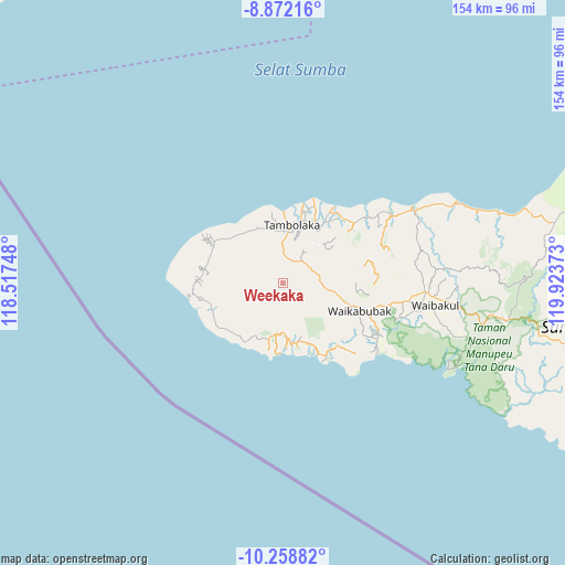
Weekaka GPS coordinates[2]
9° 33' 58.32" South, 119° 13' 14.16" East
| Map corner | latitude | longitude |
|---|---|---|
| Upper-left | -8.87216°, | 118.51748° |
| Center: | -9.5662°, | 119.2206° |
| Lower-right: | -10.25882°, | 119.92373° |
| Map W x H: | 154.2×154.2 km | = 95.8×95.8mi |
| max Lat: | 5.88969° ⇑93.5% North |
| Weekaka: | -9.5662° |
| min Lat: | ⇓6.5% South -10.934° |
| min Long | Weekaka | max Long |
| 95.1345° | 119.2206° | 140.9419° |
| W 81.2%⇐ | ⇒18.8% E |
Elevation
Elevation of Weekaka is 410 m = 1345 ft, and this is 180.3 m = 592 ft above average elevation for this country.
| Max E: |
3185 m = 10449 ft | 21.2% |
| Weekaka | 410 m 1345 ft | |
| Avg. | 229.7 m = 754 ft | |
Min E: |
-1 m = -3 ft | 78.8% |
See also: Indonesia elevation on elevation.city.
Geographical zone
Weekaka is located in South Torrid zone (between Equator and Tropic of Capricorn). Distance of Equator is 1063.7 km =661 mi to North.| Distance of | km | miles | from Weekaka |
|---|---|---|---|
| Equator | 1063.7 | 661 | to North |
| Tropic Capricorn | 1542.3 | 958.3 | to South |
| Antarctic Circle | 6337.5 | 3937.9 | to South |
| South Pole | 8943.4 | 5557.2 | to South |


Nearby cities:
15 places around Weekaka: (largest is in red/bold)
• Andelara
10.3 km =6.4 mi,  75°
75°
• Delo
3.3 km =2.1 mi,  195°
195°
• Kalembutillu
2.6 km =1.6 mi, 75°
• Malulla
7.5 km =4.7 mi,  153°
153°
• Manola
2.1 km =1.3 mi,  276°
276°
• Marokota
8.7 km =5.4 mi,  326°
326°
• Ombakamia
10.3 km =6.4 mi,  61°
61°
• Ombarade
9 km =5.6 mi,  87°
87°
• Pasolapida
10.3 km =6.4 mi,  217°
217°
• Pasonobenu
5.8 km =3.6 mi,  287°
287°
• Radamata
8.4 km =5.2 mi, 283°
• Waimangura
6.5 km =4 mi,  16°
16°
• Watulabara
6.6 km =4.1 mi,  51°
51°
• Weerame
7.8 km =4.8 mi,  69°
69°
• Weetombo
10.1 km =6.3 mi,  270°
270°
Sources, notices
• [Note1] Compared only with cities in Indonesia existing in our database
• [Src1] Map data: © OpenStreetMap contributors (CC-BY-SA)
• [Src2] Other city data from geonames.org with taken over terms of usage.
• [Src3] Geographical zone / Annual Mean Temperature by Robert A. Rohde @ Wikipedia
