Kloangrotat geodata
Kloangrotat (East Nusa Tenggara) is a seat of a fourth-order administrative division; located in Indonesia in Asia/Makassar (GMT+8) time zone. In our database, there are 407 cities with bigger population. Compared to other cities in Indonesia, 88.8% of cities are located further ↑North; 88.8% of cities are located further ←West and 78.2% of cities have lower elevation than Kloangrotat. Note1


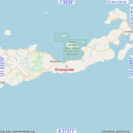
Kloangrotat GPS coordinates[2]
8° 40' 45.48" South, 122° 20' 7.8" East
| Map corner | latitude | longitude |
|---|---|---|
| Upper-left | -7.9836°, | 121.63238° |
| Center: | -8.6793°, | 122.3355° |
| Lower-right: | -9.37371°, | 123.03863° |
| Map W x H: | 154.6×154.6 km | = 96.1×96.1mi |
| max Lat: | 5.88969° ⇑88.8% North |
| Kloangrotat: | -8.6793° |
| min Lat: | ⇓11.2% South -10.934° |
| min Long | Kloangrotat | max Long |
| 95.1345° | 122.3355° | 140.9419° |
| W 88.8%⇐ | ⇒11.2% E |
Elevation
Elevation of Kloangrotat is 401 m = 1316 ft, and this is 171.3 m = 562 ft above average elevation for this country.
| Max E: |
3185 m = 10449 ft | 21.8% |
| Kloangrotat | 401 m 1316 ft | |
| Avg. | 229.7 m = 754 ft | |
Min E: |
-1 m = -3 ft | 78.2% |
See also: Indonesia elevation on elevation.city.
Geographical zone
Kloangrotat is located in South Torrid zone (between Equator and Tropic of Capricorn). Distance of Equator is 965 km =599.6 mi to North.| Distance of | km | miles | from Kloangrotat |
|---|---|---|---|
| Equator | 965 | 599.6 | to North |
| Tropic Capricorn | 1640.9 | 1019.6 | to South |
| Antarctic Circle | 6436.1 | 3999.2 | to South |
| South Pole | 9042 | 5618.4 | to South |


Nearby cities:
15 places around Kloangrotat: (largest is in red/bold)
• Aibura
1.4 km =0.9 mi,  343°
343°
• Baluk
7.8 km =4.8 mi,  205°
205°
• Baobatun
6 km =3.7 mi,  261°
261°
• Bei
7.5 km =4.7 mi,  251°
251°
• Higetegera
7.6 km =4.7 mi,  298°
298°
• Ili
7.7 km =4.8 mi,  273°
273°
• Kawapante
5.7 km =3.5 mi,  310°
310°
• Kloangpopot
4 km =2.5 mi,  153°
153°
• Magetlegar
2.8 km =1.7 mi,  140°
140°
• Nangahaledoi
5.5 km =3.4 mi, 341°
• Nitakloang
5.2 km =3.2 mi,  291°
291°
• Potet
3 km =1.9 mi, 262°
• Waipare
7.8 km =4.8 mi, 306°
• Watublapi
3.4 km =2.1 mi,  225°
225°
• Wolokoli
8.1 km =5 mi, 228°
Sources, notices
• [Note1] Compared only with cities in Indonesia existing in our database
• [Src1] Map data: © OpenStreetMap contributors (CC-BY-SA)
• [Src2] Other city data from geonames.org with taken over terms of usage.
• [Src3] Geographical zone / Annual Mean Temperature by Robert A. Rohde @ Wikipedia
