Lengor geodata
Lengor (Banten) is a seat of a fourth-order administrative division; located in Indonesia in Asia/Jakarta (GMT+7) time zone. In our database, there are 407 cities with bigger population. Compared to other cities in Indonesia, 87.3% of cities are located further ↓South; 89.3% of cities are located further →East and 63.1% of cities have lower elevation than Lengor. Note1


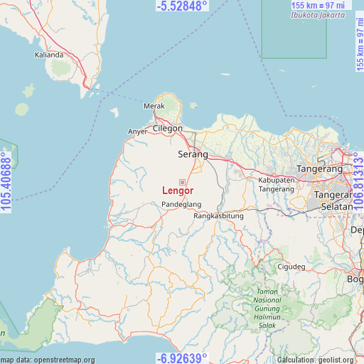
Lengor GPS coordinates[2]
6° 13' 40.44" South, 106° 6' 36" East
| Map corner | latitude | longitude |
|---|---|---|
| Upper-left | -5.52848°, | 105.40688° |
| Center: | -6.2279°, | 106.11° |
| Lower-right: | -6.92639°, | 106.81313° |
| Map W x H: | 155.4×155.4 km | = 96.6×96.6mi |
| max Lat: | 5.88969° ⇑12.7% North |
| Lengor: | -6.2279° |
| min Lat: | ⇓87.3% South -10.934° |
| min Long | Lengor | max Long |
| 95.1345° | 106.11° | 140.9419° |
| W 10.7%⇐ | ⇒89.3% E |
Elevation
Elevation of Lengor is 198 m = 650 ft, and this is 31.7 m = 104 ft below average elevation for this country.
| Max E: |
3185 m = 10449 ft | 36.9% |
| Avg. | 229.7 m = 754 ft | |
| Lengor | 198 m = 650 ft | |
Min E: |
-1 m = -3 ft | 63.1% |
See also: Indonesia elevation on elevation.city.
Geographical zone
Lengor is located in South Torrid zone (between Equator and Tropic of Capricorn). Distance of Equator is 692.5 km =430.3 mi to North.| Distance of | km | miles | from Lengor |
|---|---|---|---|
| Equator | 692.5 | 430.3 | to North |
| Tropic Capricorn | 1913.4 | 1188.9 | to South |
| Antarctic Circle | 6708.7 | 4168.6 | to South |
| South Pole | 9314.6 | 5787.8 | to South |


Nearby cities:
15 places around Lengor: (largest is in red/bold)
• Cemplang
3.9 km =2.4 mi,  266°
266°
• Cigudang
2 km =1.2 mi,  207°
207°
• Cikaung
4 km =2.5 mi,  311°
311°
• Jalanbaru
3.9 km =2.4 mi,  162°
162°
• Kaduela
3.7 km =2.3 mi,  238°
238°
• Kadukaung
2.2 km =1.4 mi,  188°
188°
• Kalibuntu
1.7 km =1.1 mi,  14°
14°
• Nagreg
2.5 km =1.6 mi,  292°
292°
• Pancanagara
4.7 km =2.9 mi,  328°
328°
• Panyirapan
1.6 km =1 mi,  114°
114°
• Sampiran
4.6 km =2.9 mi,  298°
298°
• Sindanghayu
4.5 km =2.8 mi, 187°
• Sioah
2.4 km =1.5 mi,  1°
1°
• Sukacai
1 km =0.6 mi,  176°
176°
• Tanagara
4.5 km =2.8 mi,  201°
201°
Sources, notices
• [Note1] Compared only with cities in Indonesia existing in our database
• [Src1] Map data: © OpenStreetMap contributors (CC-BY-SA)
• [Src2] Other city data from geonames.org with taken over terms of usage.
• [Src3] Geographical zone / Annual Mean Temperature by Robert A. Rohde @ Wikipedia
