Selagedang Dua geodata
Selagedang Dua (West Java) is a seat of a fourth-order administrative division; located in Indonesia in Asia/Jakarta (GMT+7) time zone. In our database, there are 407 cities with bigger population. Compared to other cities in Indonesia, 55.8% of cities are located further ↓South; 84.9% of cities are located further →East and 86.8% of cities have lower elevation than Selagedang Dua. Note1


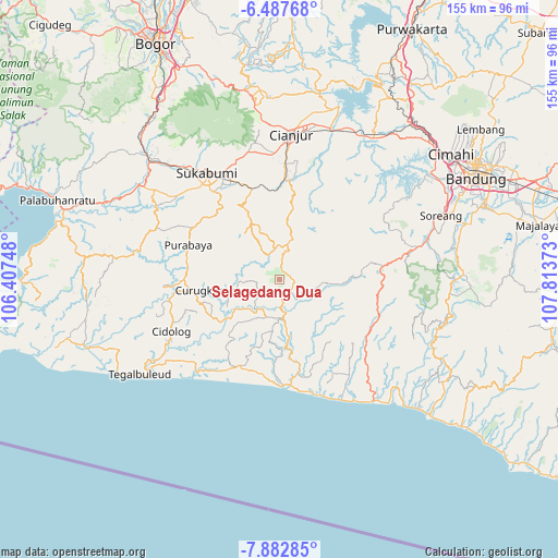
Selagedang Dua GPS coordinates[2]
7° 11' 8.88" South, 107° 6' 38.16" East
| Map corner | latitude | longitude |
|---|---|---|
| Upper-left | -6.48768°, | 106.40748° |
| Center: | -7.1858°, | 107.1106° |
| Lower-right: | -7.88285°, | 107.81373° |
| Map W x H: | 155.1×155.1 km | = 96.4×96.4mi |
| max Lat: | 5.88969° ⇑44.2% North |
| Selagedang Dua: | -7.1858° |
| min Lat: | ⇓55.8% South -10.934° |
| min Long | Selagedang Dua | max Long |
| 95.1345° | 107.1106° | 140.9419° |
| W 15.1%⇐ | ⇒84.9% E |
Elevation
Elevation of Selagedang Dua is 552 m = 1811 ft, and this is 322.3 m = 1057 ft above average elevation for this country.
| Max E: |
3185 m = 10449 ft | 13.2% |
| Selagedang Dua | 552 m 1811 ft | |
| Avg. | 229.7 m = 754 ft | |
Min E: |
-1 m = -3 ft | 86.8% |
See also: Indonesia elevation on elevation.city.
Geographical zone
Selagedang Dua is located in South Torrid zone (between Equator and Tropic of Capricorn). Distance of Equator is 799 km =496.5 mi to North.| Distance of | km | miles | from Selagedang Dua |
|---|---|---|---|
| Equator | 799 | 496.5 | to North |
| Tropic Capricorn | 1806.9 | 1122.8 | to South |
| Antarctic Circle | 6602.2 | 4102.4 | to South |
| South Pole | 9208.1 | 5721.6 | to South |


Nearby cities:
15 places around Selagedang Dua: (largest is in red/bold)
• Babakantugu
8.6 km =5.3 mi,  198°
198°
• Bebedahan
8.7 km =5.4 mi,  158°
158°
• Cibitung
7.8 km =4.8 mi,  16°
16°
• Ciduren
3.9 km =2.4 mi,  260°
260°
• Ciodeng
8.3 km =5.2 mi,  348°
348°
• Cisasak
1.7 km =1.1 mi,  116°
116°
• Gintungsari
9 km =5.6 mi,  293°
293°
• Gunungwaru Satu
9.1 km =5.7 mi,  227°
227°
• Kampungtengah
5.6 km =3.5 mi,  326°
326°
• Kebonkaret
7.5 km =4.7 mi,  214°
214°
• Legokbuluh
4.6 km =2.9 mi, 164°
• Parabon
5.3 km =3.3 mi,  6°
6°
• Sukamulya
0.9 km =0.6 mi,  269°
269°
• Sukasari
6.2 km =3.9 mi, 264°
• Tanggeung
9.2 km =5.7 mi,  171°
171°
Sources, notices
• [Note1] Compared only with cities in Indonesia existing in our database
• [Src1] Map data: © OpenStreetMap contributors (CC-BY-SA)
• [Src2] Other city data from geonames.org with taken over terms of usage.
• [Src3] Geographical zone / Annual Mean Temperature by Robert A. Rohde @ Wikipedia
