Dusundesa geodata
Dusundesa (West Java) is a seat of a fourth-order administrative division; located in Indonesia in Asia/Jakarta (GMT+7) time zone. In our database, there are 407 cities with bigger population. Compared to other cities in Indonesia, 53.4% of cities are located further ↑North; 74.9% of cities are located further →East and 74.9% of cities have lower elevation than Dusundesa. Note1


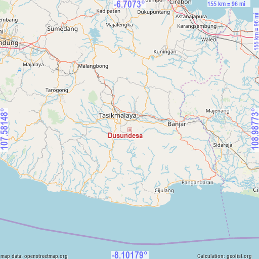
Dusundesa GPS coordinates[2]
7° 24' 18.36" South, 108° 17' 4.56" East
| Map corner | latitude | longitude |
|---|---|---|
| Upper-left | -6.7073°, | 107.58148° |
| Center: | -7.4051°, | 108.2846° |
| Lower-right: | -8.10179°, | 108.98773° |
| Map W x H: | 155.1×155.1 km | = 96.4×96.4mi |
| max Lat: | 5.88969° ⇑53.4% North |
| Dusundesa: | -7.4051° |
| min Lat: | ⇓46.6% South -10.934° |
| min Long | Dusundesa | max Long |
| 95.1345° | 108.2846° | 140.9419° |
| W 25.1%⇐ | ⇒74.9% E |
Elevation
Elevation of Dusundesa is 358 m = 1175 ft, and this is 128.3 m = 421 ft above average elevation for this country.
| Max E: |
3185 m = 10449 ft | 25.1% |
| Dusundesa | 358 m 1175 ft | |
| Avg. | 229.7 m = 754 ft | |
Min E: |
-1 m = -3 ft | 74.9% |
See also: Indonesia elevation on elevation.city.
Geographical zone
Dusundesa is located in South Torrid zone (between Equator and Tropic of Capricorn). Distance of Equator is 823.4 km =511.6 mi to North.| Distance of | km | miles | from Dusundesa |
|---|---|---|---|
| Equator | 823.4 | 511.6 | to North |
| Tropic Capricorn | 1782.5 | 1107.6 | to South |
| Antarctic Circle | 6577.8 | 4087.3 | to South |
| South Pole | 9183.7 | 5706.5 | to South |


Nearby cities:
15 places around Dusundesa: (largest is in red/bold)
• Bandung
2.7 km =1.7 mi,  283°
283°
• Bojongsari
3.1 km =1.9 mi,  60°
60°
• Cidamar
4.2 km =2.6 mi,  154°
154°
• Cimuncang
5.2 km =3.2 mi,  14°
14°
• Cinunjang
1.7 km =1.1 mi,  184°
184°
• Gunajaya
3.8 km =2.4 mi,  346°
346°
• Jatiwangi
4.2 km =2.6 mi,  315°
315°
• Kadupandak
5.1 km =3.2 mi, 316°
• Lengkong
1.2 km =0.7 mi,  20°
20°
• Nyemplong
4.3 km =2.7 mi,  250°
250°
• Panuusan
3.1 km =1.9 mi,  98°
98°
• Poponcol
2.8 km =1.7 mi, 150°
• Sukamaju
4.6 km =2.9 mi,  70°
70°
• Sukamulya
3 km =1.9 mi, 7°
• Sukasirna
4.5 km =2.8 mi, 350°
Sources, notices
• [Note1] Compared only with cities in Indonesia existing in our database
• [Src1] Map data: © OpenStreetMap contributors (CC-BY-SA)
• [Src2] Other city data from geonames.org with taken over terms of usage.
• [Src3] Geographical zone / Annual Mean Temperature by Robert A. Rohde @ Wikipedia
