Bawi Kulon geodata
Bawi Kulon (East Java) is a seat of a fourth-order administrative division; located in Indonesia in Asia/Jakarta (GMT+7) time zone. In our database, there are 407 cities with bigger population. Compared to other cities in Indonesia, 70.6% of cities are located further ↓South; 51.9% of cities are located further →East and 65.3% of cities have lower elevation than Bawi Kulon. Note1


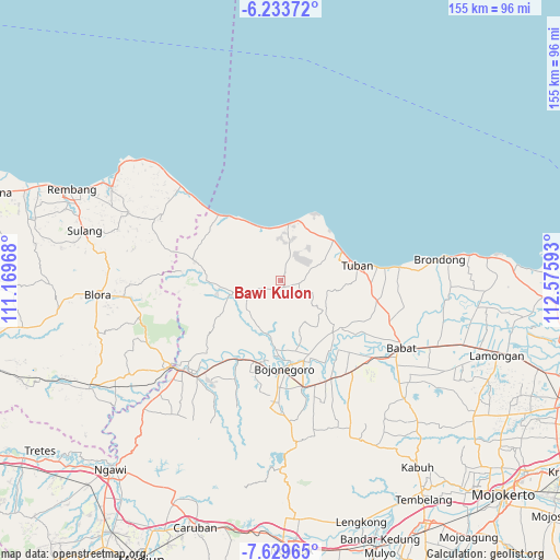
Bawi Kulon GPS coordinates[2]
6° 55' 55.92" South, 111° 52' 22.08" East
| Map corner | latitude | longitude |
|---|---|---|
| Upper-left | -6.23372°, | 111.16968° |
| Center: | -6.9322°, | 111.8728° |
| Lower-right: | -7.62965°, | 112.57593° |
| Map W x H: | 155.2×155.2 km | = 96.4×96.4mi |
| max Lat: | 5.88969° ⇑29.4% North |
| Bawi Kulon: | -6.9322° |
| min Lat: | ⇓70.6% South -10.934° |
| min Long | Bawi Kulon | max Long |
| 95.1345° | 111.8728° | 140.9419° |
| W 48.1%⇐ | ⇒51.9% E |
Elevation
Elevation of Bawi Kulon is 226 m = 741 ft, and this is 3.7 m = 12 ft below average elevation for this country.
| Max E: |
3185 m = 10449 ft | 34.7% |
| Avg. | 229.7 m = 754 ft | |
| Bawi Kulon | 226 m = 741 ft | |
Min E: |
-1 m = -3 ft | 65.3% |
See also: Indonesia elevation on elevation.city.
Geographical zone
Bawi Kulon is located in South Torrid zone (between Equator and Tropic of Capricorn). Distance of Equator is 770.8 km =479 mi to North.| Distance of | km | miles | from Bawi Kulon |
|---|---|---|---|
| Equator | 770.8 | 479 | to North |
| Tropic Capricorn | 1835.1 | 1140.3 | to South |
| Antarctic Circle | 6630.4 | 4119.9 | to South |
| South Pole | 9236.3 | 5739.2 | to South |


Nearby cities:
15 places around Bawi Kulon: (largest is in red/bold)
• Bean
4.7 km =2.9 mi,  138°
138°
• Guwoterus
5.5 km =3.4 mi,  244°
244°
• Jarurejo
3.8 km =2.4 mi,  20°
20°
• Jetak
4.6 km =2.9 mi,  125°
125°
• Kerek
4.4 km =2.7 mi, 20°
• Margorejo
4.5 km =2.8 mi,  6°
6°
• Montongsekar
2.1 km =1.3 mi,  154°
154°
• Padasan
4.6 km =2.9 mi,  47°
47°
• Pakel
3.8 km =2.4 mi, 135°
• Pucangan
3.3 km =2.1 mi,  113°
113°
• Sidonganti
5.8 km =3.6 mi,  281°
281°
• Talangkembar
3.2 km =2 mi,  209°
209°
• Talun
5.5 km =3.4 mi,  115°
115°
• Temayang
3.7 km =2.3 mi,  30°
30°
• Tengger
3.1 km =1.9 mi,  300°
300°
Sources, notices
• [Note1] Compared only with cities in Indonesia existing in our database
• [Src1] Map data: © OpenStreetMap contributors (CC-BY-SA)
• [Src2] Other city data from geonames.org with taken over terms of usage.
• [Src3] Geographical zone / Annual Mean Temperature by Robert A. Rohde @ Wikipedia
