Obelobel geodata
Obelobel (West Nusa Tenggara) is a seat of a fourth-order administrative division; located in Indonesia in Asia/Makassar (GMT+8) time zone. In our database, there are 407 cities with bigger population. Compared to other cities in Indonesia, 75% of cities are located further ↑North; 77.8% of cities are located further ←West and 89% of cities have higher elevation than Obelobel. Note1


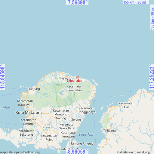
Obelobel GPS coordinates[2]
8° 15' 55.44" South, 116° 32' 56.76" East
| Map corner | latitude | longitude |
|---|---|---|
| Upper-left | -7.56898°, | 115.84598° |
| Center: | -8.2654°, | 116.5491° |
| Lower-right: | -8.96059°, | 117.25223° |
| Map W x H: | 154.7×154.7 km | = 96.1×96.1mi |
| max Lat: | 5.88969° ⇑75% North |
| Obelobel: | -8.2654° |
| min Lat: | ⇓25% South -10.934° |
| min Long | Obelobel | max Long |
| 95.1345° | 116.5491° | 140.9419° |
| W 77.8%⇐ | ⇒22.2% E |
Elevation
Elevation of Obelobel is 11 m = 36 ft, and this is 218.7 m = 718 ft below average elevation for this country.
| Max E: |
3185 m = 10449 ft | 89% |
| Avg. | 229.7 m = 754 ft | |
| Obelobel | 11 m = 36 ft | |
Min E: |
-1 m = -3 ft | 11% |
See also: Indonesia elevation on elevation.city.
Geographical zone
Obelobel is located in South Torrid zone (between Equator and Tropic of Capricorn). Distance of Equator is 919 km =571 mi to North.| Distance of | km | miles | from Obelobel |
|---|---|---|---|
| Equator | 919 | 571 | to North |
| Tropic Capricorn | 1686.9 | 1048.2 | to South |
| Antarctic Circle | 6482.1 | 4027.8 | to South |
| South Pole | 9088 | 5647 | to South |


Nearby cities:
15 places around Obelobel: (largest is in red/bold)
• Akarakar
23.2 km =14.4 mi,  282°
282°
• Anyar
14.2 km =8.8 mi,  286°
286°
• Bayan
13.6 km =8.5 mi,  268°
268°
• Belanting
9.7 km =6 mi,  117°
117°
• Gubuk Daya
28.9 km =18 mi,  174°
174°
• Kampungbaru
29.2 km =18.1 mi,  154°
154°
• Karanggedang
17.2 km =10.7 mi, 286°
• Labuan Lombok
29.1 km =18.1 mi, 153°
• Lelongken
8.6 km =5.3 mi,  222°
222°
• Loloan
12.1 km =7.5 mi, 274°
• Montongkemong
25 km =15.5 mi,  178°
178°
• Sambelia
19.7 km =12.2 mi,  129°
129°
• Sembalunbumbung
13.3 km =8.3 mi, 182°
• Sembalunlawang
11 km =6.8 mi,  188°
188°
• Tampes
27.5 km =17.1 mi, 277°
Sources, notices
• [Note1] Compared only with cities in Indonesia existing in our database
• [Src1] Map data: © OpenStreetMap contributors (CC-BY-SA)
• [Src2] Other city data from geonames.org with taken over terms of usage.
• [Src3] Geographical zone / Annual Mean Temperature by Robert A. Rohde @ Wikipedia
