Bengubelan geodata
Bengubelan (East Nusa Tenggara) is a seat of a fourth-order administrative division; located in Indonesia in Asia/Makassar (GMT+8) time zone. In our database, there are 407 cities with bigger population. Compared to other cities in Indonesia, 99.6% of cities are located further ↑North; 91.4% of cities are located further ←West and 77.1% of cities have higher elevation than Bengubelan. Note1


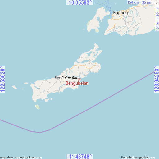
Bengubelan GPS coordinates[2]
10° 44' 51" South, 123° 14' 21.84" East
| Map corner | latitude | longitude |
|---|---|---|
| Upper-left | -10.05593°, | 122.53628° |
| Center: | -10.7475°, | 123.2394° |
| Lower-right: | -11.43748°, | 123.94253° |
| Map W x H: | 153.6×153.6 km | = 95.4×95.4mi |
| max Lat: | 5.88969° ⇑99.6% North |
| Bengubelan: | -10.7475° |
| min Lat: | ⇓0.4% South -10.934° |
| min Long | Bengubelan | max Long |
| 95.1345° | 123.2394° | 140.9419° |
| W 91.4%⇐ | ⇒8.6% E |
Elevation
Elevation of Bengubelan is 22 m = 72 ft, and this is 207.7 m = 681 ft below average elevation for this country.
| Max E: |
3185 m = 10449 ft | 77.1% |
| Avg. | 229.7 m = 754 ft | |
| Bengubelan | 22 m = 72 ft | |
Min E: |
-1 m = -3 ft | 22.9% |
See also: Indonesia elevation on elevation.city.
Geographical zone
Bengubelan is located in South Torrid zone (between Equator and Tropic of Capricorn). Distance of Equator is 1195 km =742.5 mi to North.| Distance of | km | miles | from Bengubelan |
|---|---|---|---|
| Equator | 1195 | 742.5 | to North |
| Tropic Capricorn | 1410.9 | 876.7 | to South |
| Antarctic Circle | 6206.2 | 3856.4 | to South |
| South Pole | 8812.1 | 5475.6 | to South |


Nearby cities:
15 places around Bengubelan: (largest is in red/bold)
• Batulilok Satu
1.3 km =0.8 mi,  13°
13°
• Bebengu
9.6 km =6 mi,  55°
55°
• Folaoen Satu
5.7 km =3.5 mi,  195°
195°
• Kakaek
2.7 km =1.7 mi,  50°
50°
• Kolla
13.4 km =8.3 mi,  318°
318°
• Kolobolon
12.9 km =8 mi,  241°
241°
• Momanalu
14.2 km =8.8 mi,  311°
311°
• Nggenamadale
4.9 km =3 mi,  251°
251°
• Nitanggoeng
9.1 km =5.7 mi,  295°
295°
• Oele
9.7 km =6 mi, 244°
• Olafulihaa
13 km =8.1 mi,  357°
357°
• Puamata
11.8 km =7.3 mi,  278°
278°
• Puan Selatan
6.7 km =4.2 mi, 56°
• Seda
3.6 km =2.2 mi,  226°
226°
• Sua
14.3 km =8.9 mi, 10°
Sources, notices
• [Note1] Compared only with cities in Indonesia existing in our database
• [Src1] Map data: © OpenStreetMap contributors (CC-BY-SA)
• [Src2] Other city data from geonames.org with taken over terms of usage.
• [Src3] Geographical zone / Annual Mean Temperature by Robert A. Rohde @ Wikipedia
