Rapas geodata
Rapas (East Java) is a seat of a fourth-order administrative division; located in Indonesia in Asia/Jakarta (GMT+7) time zone. In our database, there are 407 cities with bigger population. Compared to other cities in Indonesia, 70.4% of cities are located further ↓South; 62.3% of cities are located further ←West and 54% of cities have lower elevation than Rapas. Note1


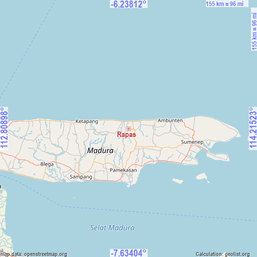
Rapas GPS coordinates[2]
6° 56' 11.76" South, 113° 30' 43.56" East
| Map corner | latitude | longitude |
|---|---|---|
| Upper-left | -6.23812°, | 112.80898° |
| Center: | -6.9366°, | 113.5121° |
| Lower-right: | -7.63404°, | 114.21523° |
| Map W x H: | 155.2×155.2 km | = 96.4×96.4mi |
| max Lat: | 5.88969° ⇑29.6% North |
| Rapas: | -6.9366° |
| min Lat: | ⇓70.4% South -10.934° |
| min Long | Rapas | max Long |
| 95.1345° | 113.5121° | 140.9419° |
| W 62.3%⇐ | ⇒37.7% E |
Elevation
Elevation of Rapas is 119 m = 390 ft, and this is 110.7 m = 363 ft below average elevation for this country.
| Max E: |
3185 m = 10449 ft | 46% |
| Avg. | 229.7 m = 754 ft | |
| Rapas | 119 m = 390 ft | |
Min E: |
-1 m = -3 ft | 54% |
See also: Indonesia elevation on elevation.city.
Geographical zone
Rapas is located in South Torrid zone (between Equator and Tropic of Capricorn). Distance of Equator is 771.3 km =479.3 mi to North.| Distance of | km | miles | from Rapas |
|---|---|---|---|
| Equator | 771.3 | 479.3 | to North |
| Tropic Capricorn | 1834.6 | 1140 | to South |
| Antarctic Circle | 6629.9 | 4119.6 | to South |
| South Pole | 9235.8 | 5738.9 | to South |


Nearby cities:
15 places around Rapas: (largest is in red/bold)
• Baban
2.6 km =1.6 mi,  295°
295°
• Bandungan Timur
4 km =2.5 mi,  221°
221°
• Brumbung Laok
1.2 km =0.7 mi,  24°
24°
• Danpateh
2.8 km =1.7 mi,  73°
73°
• Kalebun
3.2 km =2 mi,  256°
256°
• Lonpao Dajah
4.9 km =3 mi,  328°
328°
• Rokem Barat
4.9 km =3 mi,  26°
26°
• Sangoleng
4.1 km =2.5 mi,  3°
3°
• Tamberu
5.3 km =3.3 mi,  324°
324°
• Telangi Satu
3.9 km =2.4 mi,  104°
104°
• Tengah
3.3 km =2.1 mi,  55°
55°
• Tengah
4.4 km =2.7 mi,  82°
82°
• Timur Dajah
4.5 km =2.8 mi,  13°
13°
• Wakduwa’ Barat
1.7 km =1.1 mi, 100°
• Waru
4.2 km =2.6 mi, 98°
Sources, notices
• [Note1] Compared only with cities in Indonesia existing in our database
• [Src1] Map data: © OpenStreetMap contributors (CC-BY-SA)
• [Src2] Other city data from geonames.org with taken over terms of usage.
• [Src3] Geographical zone / Annual Mean Temperature by Robert A. Rohde @ Wikipedia
