Bandungan Timur geodata
Bandungan Timur (East Java) is a seat of a fourth-order administrative division; located in Indonesia in Asia/Jakarta (GMT+7) time zone. In our database, there are 407 cities with bigger population. Compared to other cities in Indonesia, 68.8% of cities are located further ↓South; 62% of cities are located further ←West and 56.7% of cities have lower elevation than Bandungan Timur. Note1


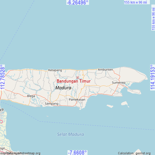
Bandungan Timur GPS coordinates[2]
6° 57' 48.24" South, 113° 29' 18.24" East
| Map corner | latitude | longitude |
|---|---|---|
| Upper-left | -6.26496°, | 112.78528° |
| Center: | -6.9634°, | 113.4884° |
| Lower-right: | -7.6608°, | 114.19153° |
| Map W x H: | 155.2×155.2 km | = 96.4×96.4mi |
| max Lat: | 5.88969° ⇑31.2% North |
| Bandungan Timur: | -6.9634° |
| min Lat: | ⇓68.8% South -10.934° |
| min Long | Bandungan Timur | max Long |
| 95.1345° | 113.4884° | 140.9419° |
| W 62%⇐ | ⇒38% E |
Elevation
Elevation of Bandungan Timur is 135 m = 443 ft, and this is 94.7 m = 311 ft below average elevation for this country.
| Max E: |
3185 m = 10449 ft | 43.3% |
| Avg. | 229.7 m = 754 ft | |
| Bandungan Timur | 135 m = 443 ft | |
Min E: |
-1 m = -3 ft | 56.7% |
See also: Indonesia elevation on elevation.city.
Geographical zone
Bandungan Timur is located in South Torrid zone (between Equator and Tropic of Capricorn). Distance of Equator is 774.3 km =481.1 mi to North.| Distance of | km | miles | from Bandungan Timur |
|---|---|---|---|
| Equator | 774.3 | 481.1 | to North |
| Tropic Capricorn | 1831.7 | 1138.2 | to South |
| Antarctic Circle | 6626.9 | 4117.8 | to South |
| South Pole | 9232.8 | 5737 | to South |


Nearby cities:
15 places around Bandungan Timur: (largest is in red/bold)
• Baban
4.1 km =2.5 mi,  4°
4°
• Brumbung Laok
5.1 km =3.2 mi,  37°
37°
• Danpateh
6.6 km =4.1 mi,  54°
54°
• Gunungtengah
7 km =4.3 mi,  91°
91°
• Kalebun
2.3 km =1.4 mi,  346°
346°
• Kranjih
5.2 km =3.2 mi,  306°
306°
• Nomih
2.2 km =1.4 mi,  187°
187°
• Nongkesan
5 km =3.1 mi,  321°
321°
• Paolasen
6.3 km =3.9 mi,  129°
129°
• Pregi
6 km =3.7 mi,  109°
109°
• Rapas
4 km =2.5 mi, 41°
• Secang Barat
5.3 km =3.3 mi,  257°
257°
• Telangi Satu
6.7 km =4.2 mi,  72°
72°
• Trebungonjur
5.8 km =3.6 mi,  150°
150°
• Wakduwa’ Barat
5.1 km =3.2 mi,  58°
58°
Sources, notices
• [Note1] Compared only with cities in Indonesia existing in our database
• [Src1] Map data: © OpenStreetMap contributors (CC-BY-SA)
• [Src2] Other city data from geonames.org with taken over terms of usage.
• [Src3] Geographical zone / Annual Mean Temperature by Robert A. Rohde @ Wikipedia
