Neto geodata
Neto (East Nusa Tenggara) is a seat of a fourth-order administrative division; located in Indonesia in Asia/Makassar (GMT+8) time zone. In our database, there are 407 cities with bigger population. Compared to other cities in Indonesia, 95.8% of cities are located further ↑North; 95.9% of cities are located further ←West and 95% of cities have lower elevation than Neto. Note1


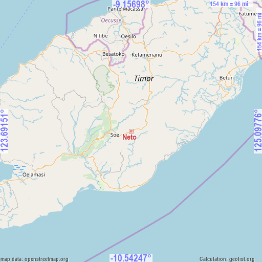
Neto GPS coordinates[2]
9° 51' 1.62" South, 124° 23' 40.668" East
| Map corner | latitude | longitude |
|---|---|---|
| Upper-left | -9.15698°, | 123.69151° |
| Center: | -9.85045°, | 124.39463° |
| Lower-right: | -10.54247°, | 125.09776° |
| Map W x H: | 154.1×154.1 km | = 95.8×95.8mi |
| max Lat: | 5.88969° ⇑95.8% North |
| Neto: | -9.85045° |
| min Lat: | ⇓4.2% South -10.934° |
| min Long | Neto | max Long |
| 95.1345° | 124.39463° | 140.9419° |
| W 95.9%⇐ | ⇒4.1% E |
Elevation
Elevation of Neto is 821 m = 2694 ft, and this is 591.3 m = 1940 ft above average elevation for this country.
| Max E: |
3185 m = 10449 ft | 5% |
| Neto | 821 m 2694 ft | |
| Avg. | 229.7 m = 754 ft | |
Min E: |
-1 m = -3 ft | 95% |
See also: Indonesia elevation on elevation.city.
Geographical zone
Neto is located in South Torrid zone (between Equator and Tropic of Capricorn). Distance of Equator is 1095.3 km =680.6 mi to North.| Distance of | km | miles | from Neto |
|---|---|---|---|
| Equator | 1095.3 | 680.6 | to North |
| Tropic Capricorn | 1510.7 | 938.7 | to South |
| Antarctic Circle | 6305.9 | 3918.3 | to South |
| South Pole | 8911.8 | 5537.5 | to South |


Nearby cities:
15 places around Neto: (largest is in red/bold)
• Belua
9.4 km =5.8 mi,  191°
191°
• Bone
8.6 km =5.3 mi,  61°
61°
• Hoi
5.8 km =3.6 mi,  47°
47°
• Kusi
3.8 km =2.4 mi,  246°
246°
• Mio
5.8 km =3.6 mi,  279°
279°
• Naukae
4.9 km =3 mi, 54°
• Neonmat
7.4 km =4.6 mi, 247°
• Nobinobi
7.2 km =4.5 mi,  76°
76°
• Noebesa
7.7 km =4.8 mi,  95°
95°
• Oefatu
2.3 km =1.4 mi, 100°
• Oepula
6.8 km =4.2 mi, 248°
• Polo Satu
7.6 km =4.7 mi,  325°
325°
• Pusu
9.6 km =6 mi,  237°
237°
• Supul
5.8 km =3.6 mi, 83°
• Tetaf
4.5 km =2.8 mi,  68°
68°
Sources, notices
• [Note1] Compared only with cities in Indonesia existing in our database
• [Src1] Map data: © OpenStreetMap contributors (CC-BY-SA)
• [Src2] Other city data from geonames.org with taken over terms of usage.
• [Src3] Geographical zone / Annual Mean Temperature by Robert A. Rohde @ Wikipedia
