Naukae geodata
Naukae (East Nusa Tenggara) is a seat of a fourth-order administrative division; located in Indonesia in Asia/Makassar (GMT+8) time zone. In our database, there are 407 cities with bigger population. Compared to other cities in Indonesia, 95.6% of cities are located further ↑North; 96% of cities are located further ←West and 95.7% of cities have lower elevation than Naukae. Note1


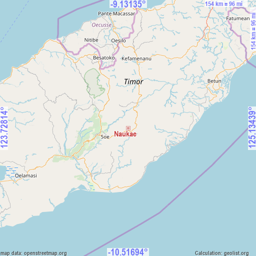
Naukae GPS coordinates[2]
9° 49' 29.532" South, 124° 25' 52.536" East
| Map corner | latitude | longitude |
|---|---|---|
| Upper-left | -9.13135°, | 123.72814° |
| Center: | -9.82487°, | 124.43126° |
| Lower-right: | -10.51694°, | 125.13439° |
| Map W x H: | 154.1×154.1 km | = 95.8×95.8mi |
| max Lat: | 5.88969° ⇑95.6% North |
| Naukae: | -9.82487° |
| min Lat: | ⇓4.4% South -10.934° |
| min Long | Naukae | max Long |
| 95.1345° | 124.43126° | 140.9419° |
| W 96%⇐ | ⇒4% E |
Elevation
Elevation of Naukae is 857 m = 2812 ft, and this is 627.3 m = 2058 ft above average elevation for this country.
| Max E: |
3185 m = 10449 ft | 4.3% |
| Naukae | 857 m 2812 ft | |
| Avg. | 229.7 m = 754 ft | |
Min E: |
-1 m = -3 ft | 95.7% |
See also: Indonesia elevation on elevation.city.
Geographical zone
Naukae is located in South Torrid zone (between Equator and Tropic of Capricorn). Distance of Equator is 1092.4 km =678.8 mi to North.| Distance of | km | miles | from Naukae |
|---|---|---|---|
| Equator | 1092.4 | 678.8 | to North |
| Tropic Capricorn | 1513.5 | 940.4 | to South |
| Antarctic Circle | 6308.8 | 3920.1 | to South |
| South Pole | 8914.6 | 5539.3 | to South |


Nearby cities:
15 places around Naukae: (largest is in red/bold)
• Bone
3.8 km =2.4 mi,  70°
70°
• Fatubia
8.8 km =5.5 mi,  86°
86°
• Hoi
1.1 km =0.7 mi,  14°
14°
• Kusi
8.7 km =5.4 mi,  239°
239°
• Melahue
8.4 km =5.2 mi,  343°
343°
• Neosob
9 km =5.6 mi,  37°
37°
• Neto
4.9 km =3 mi,  234°
234°
• Nikiniki
5.1 km =3.2 mi,  75°
75°
• Nobinobi
3.2 km =2 mi,  111°
111°
• Noebesa
5.1 km =3.2 mi,  135°
135°
• Oefatu
3.7 km =2.3 mi,  208°
208°
• Sopo
7.4 km =4.6 mi, 40°
• Supul
2.8 km =1.7 mi, 141°
• Tetaf
1.2 km =0.7 mi,  172°
172°
• Tumu
7.4 km =4.6 mi,  118°
118°
Sources, notices
• [Note1] Compared only with cities in Indonesia existing in our database
• [Src1] Map data: © OpenStreetMap contributors (CC-BY-SA)
• [Src2] Other city data from geonames.org with taken over terms of usage.
• [Src3] Geographical zone / Annual Mean Temperature by Robert A. Rohde @ Wikipedia
