Nobinobi geodata
Nobinobi (East Nusa Tenggara) is a seat of a fourth-order administrative division; located in Indonesia in Asia/Makassar (GMT+8) time zone. In our database, there are 407 cities with bigger population. Compared to other cities in Indonesia, 95.6% of cities are located further ↑North; 96.2% of cities are located further ←West and 95.6% of cities have lower elevation than Nobinobi. Note1


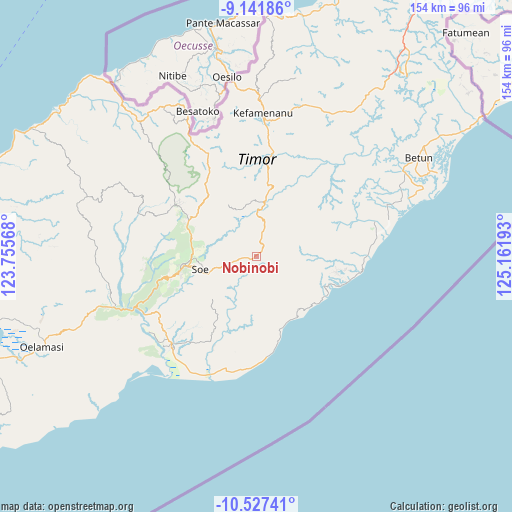
Nobinobi GPS coordinates[2]
9° 50' 7.296" South, 124° 27' 31.68" East
| Map corner | latitude | longitude |
|---|---|---|
| Upper-left | -9.14186°, | 123.75568° |
| Center: | -9.83536°, | 124.4588° |
| Lower-right: | -10.52741°, | 125.16193° |
| Map W x H: | 154.1×154.1 km | = 95.8×95.8mi |
| max Lat: | 5.88969° ⇑95.6% North |
| Nobinobi: | -9.83536° |
| min Lat: | ⇓4.4% South -10.934° |
| min Long | Nobinobi | max Long |
| 95.1345° | 124.4588° | 140.9419° |
| W 96.2%⇐ | ⇒3.8% E |
Elevation
Elevation of Nobinobi is 850 m = 2789 ft, and this is 620.3 m = 2035 ft above average elevation for this country.
| Max E: |
3185 m = 10449 ft | 4.4% |
| Nobinobi | 850 m 2789 ft | |
| Avg. | 229.7 m = 754 ft | |
Min E: |
-1 m = -3 ft | 95.6% |
See also: Indonesia elevation on elevation.city.
Geographical zone
Nobinobi is located in South Torrid zone (between Equator and Tropic of Capricorn). Distance of Equator is 1093.6 km =679.5 mi to North.| Distance of | km | miles | from Nobinobi |
|---|---|---|---|
| Equator | 1093.6 | 679.5 | to North |
| Tropic Capricorn | 1512.3 | 939.7 | to South |
| Antarctic Circle | 6307.6 | 3919.4 | to South |
| South Pole | 8913.5 | 5538.6 | to South |


Nearby cities:
15 places around Nobinobi: (largest is in red/bold)
• Bone
2.5 km =1.6 mi,  13°
13°
• Fatubia
6 km =3.7 mi,  73°
73°
• Feuknoni
6.5 km =4 mi,  104°
104°
• Hoi
3.5 km =2.2 mi,  309°
309°
• Naukae
3.2 km =2 mi,  291°
291°
• Neto
7.2 km =4.5 mi,  256°
256°
• Nikiniki
3.1 km =1.9 mi,  38°
38°
• Noebesa
2.5 km =1.6 mi,  166°
166°
• Oefatu
5.2 km =3.2 mi,  246°
246°
• Pili
8.3 km =5.2 mi, 38°
• Sopo
7 km =4.3 mi, 14°
• Supul
1.6 km =1 mi,  232°
232°
• Tetaf
2.9 km =1.8 mi,  269°
269°
• Tumu
4.2 km =2.6 mi,  124°
124°
• Tumu
7.2 km =4.5 mi,  144°
144°
Sources, notices
• [Note1] Compared only with cities in Indonesia existing in our database
• [Src1] Map data: © OpenStreetMap contributors (CC-BY-SA)
• [Src2] Other city data from geonames.org with taken over terms of usage.
• [Src3] Geographical zone / Annual Mean Temperature by Robert A. Rohde @ Wikipedia
